You are here: Home > Network List > US - United States National Seismic Network Stations List
> Station NHSC New Hope, South Carolina, USA > Earthquake Result Viewer
NHSC New Hope, South Carolina, USA - Earthquake Result Viewer
| Earthquake location: |
Southern Bolivia |
| Earthquake latitude/longitude: |
-19.5/-66.3 |
| Earthquake time(UTC): |
2001/06/29 (180) 18:35:51 GMT |
| Earthquake Depth: |
274 km |
| Earthquake Magnitude: |
5.7 MB, 6.1 MW, 6.1 MW |
| Earthquake Catalog/Contributor: |
WHDF/NEIC |
|
| Network: |
US United States National Seismic Network |
| Station: |
NHSC New Hope, South Carolina, USA |
| Lat/Lon: |
33.11 N/80.18 W |
| Elevation: |
11 m |
|
| Distance: |
54.0 deg |
| Az: |
345.543 deg |
| Baz: |
163.707 deg |
| Ray Param: |
0.064736076 |
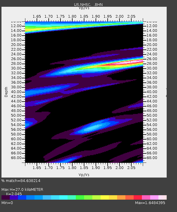
| Estimated Moho Depth: |
27.0 km |
| Estimated Crust Vp/Vs: |
2.05 |
| Assumed Crust Vp: |
6.565 km/s |
| Estimated Crust Vs: |
3.21 km/s |
| Estimated Crust Poisson's Ratio: |
0.34 |
|
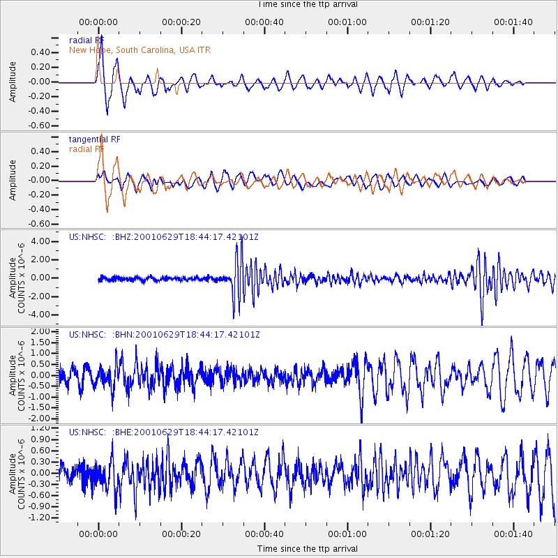
| Radial Match: |
84.638214 % |
| Radial Bump: |
336 |
| Transverse Match: |
62.544342 % |
| Transverse Bump: |
400 |
| SOD ConfigId: |
110165 |
| Insert Time: |
2010-03-05 02:06:44.653 +0000 |
| GWidth: |
2.5 |
| Max Bumps: |
400 |
| Tol: |
0.001 |
|
Signal To Noise
| Channel | StoN | STA | LTA |
| US:NHSC: :BHN:20010629T18:44:17.42101Z | 1.0974543 | 4.9214134E-7 | 4.48439E-7 |
| US:NHSC: :BHE:20010629T18:44:17.42101Z | 1.1400893 | 3.941125E-7 | 3.4568566E-7 |
| US:NHSC: :BHZ:20010629T18:44:17.42101Z | 12.026752 | 1.9974534E-6 | 1.6608418E-7 |
| Arrivals |
| Ps | 4.5 SECOND |
| PpPs | 12 SECOND |
| PsPs/PpSs | 16 SECOND |


