You are here: Home > Network List > AE - Arizona Broadband Seismic Network Stations List
> Station DUN6 Lazy B Ranch > Earthquake Result Viewer
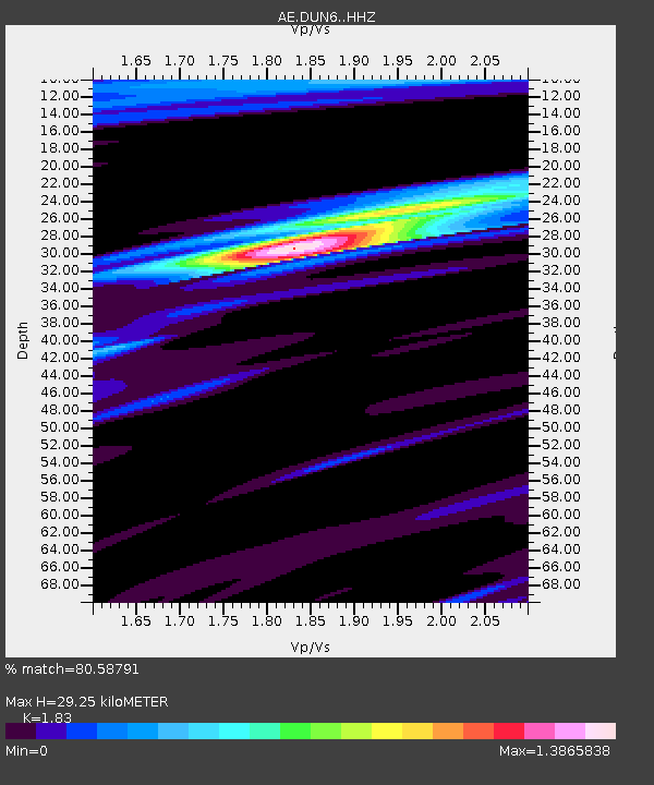
DUN6 Lazy B Ranch - Earthquake Result Viewer
| Earthquake location: |
Near Coast Of Ecuador |
| Earthquake latitude/longitude: |
0.6/-80.3 |
| Earthquake time(UTC): |
2016/04/23 (114) 01:24:34 GMT |
| Earthquake Depth: |
10 km |
| Earthquake Magnitude: |
5.8 MWP |
| Earthquake Catalog/Contributor: |
NEIC PDE/NEIC COMCAT |
|
| Network: |
AE Arizona Broadband Seismic Network |
| Station: |
DUN6 Lazy B Ranch |
| Lat/Lon: |
32.55 N/109.09 W |
| Elevation: |
1259 m |
|
| Distance: |
41.8 deg |
| Az: |
322.355 deg |
| Baz: |
133.683 deg |
| Ray Param: |
0.07356117 |
| Estimated Moho Depth: |
29.25 km |
| Estimated Crust Vp/Vs: |
1.83 |
| Assumed Crust Vp: |
6.276 km/s |
| Estimated Crust Vs: |
3.429 km/s |
| Estimated Crust Poisson's Ratio: |
0.29 |
|
| Radial Match: |
80.58791 % |
| Radial Bump: |
287 |
| Transverse Match: |
56.132824 % |
| Transverse Bump: |
400 |
| SOD ConfigId: |
7422571 |
| Insert Time: |
2019-04-22 10:46:46.886 +0000 |
| GWidth: |
2.5 |
| Max Bumps: |
400 |
| Tol: |
0.001 |
|

Signal To Noise
| Channel | StoN | STA | LTA |
| AE:DUN6: :HHZ:20160423T01:31:52.700012Z | 4.165985 | 2.6530402E-6 | 6.368339E-7 |
| AE:DUN6: :HHN:20160423T01:31:52.700012Z | 2.2148836 | 9.775767E-7 | 4.413671E-7 |
| AE:DUN6: :HHE:20160423T01:31:52.700012Z | 1.9975036 | 1.2509654E-6 | 6.262644E-7 |
| Arrivals |
| Ps | 4.1 SECOND |
| PpPs | 12 SECOND |
| PsPs/PpSs | 17 SECOND |


