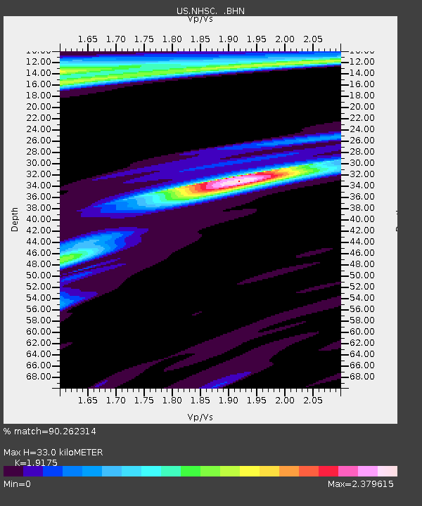
NHSC New Hope, South Carolina, USA - Earthquake Result Viewer
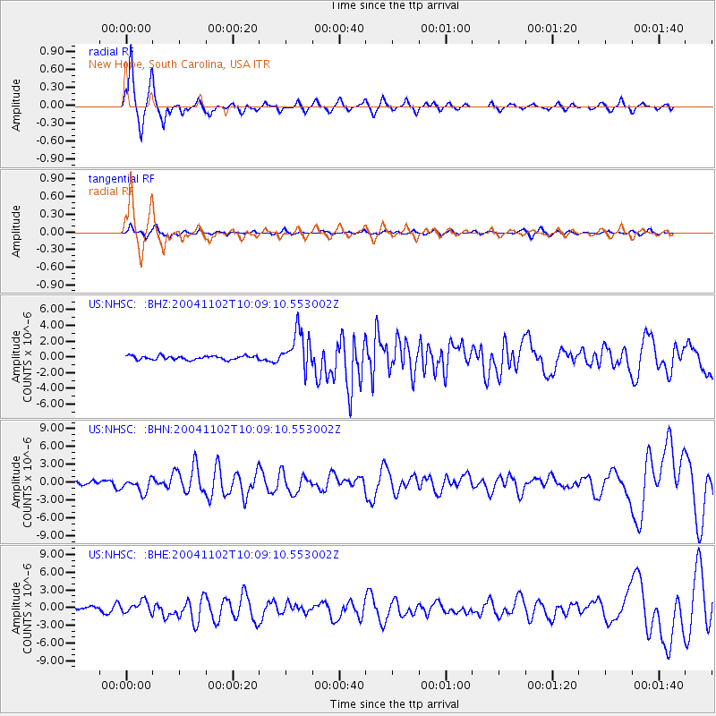
Earthquake location: Vancouver Island, Canada Region
Earthquake latitude/longitude: 49.3/-128.8
Earthquake time(UTC): 2004/11/02 (307) 10:02:12 GMT
Earthquake Depth: 10 km
Earthquake Magnitude: 5.8 MB, 6.4 MS, 6.7 MW, 6.6 MW
Earthquake Catalog/Contributor: WHDF/NEIC
Network: US United States National Seismic Network
Station: NHSC New Hope, South Carolina, USA
Lat/Lon: 33.11 N/80.18 W
Elevation: 11 m
Distance: 39.3 deg
Az: 95.758 deg
Baz: 309.072 deg
Ray Param: 0.07509203
Estimated Moho Depth: 33.0 km
Estimated Crust Vp/Vs: 1.92
Assumed Crust Vp: 6.565 km/s
Estimated Crust Vs: 3.423 km/s
Estimated Crust Poisson's Ratio: 0.31
Radial Match: 90.262314 %
Radial Bump: 349
Transverse Match: 68.953384 %
Transverse Bump: 400
SOD ConfigId: 110177
Insert Time: 2010-03-05 02:07:14.152 +0000
GWidth: 2.5
Max Bumps: 400
Tol: 0.001

Signal To Noise

ChannelStoNSTALTA
US:NHSC: :BHN:20041102T10:09:10.553002Z2.60135961.1873321E-64.5642753E-7
US:NHSC: :BHE:20041102T10:09:10.553002Z2.56395861.0160389E-63.9627744E-7
US:NHSC: :BHZ:20041102T10:09:10.553002Z10.3833242.4687615E-62.3776215E-7
Arrivals
Ps4.9 SECOND
PpPs14 SECOND
PsPs/PpSs19 SECOND