You are here: Home > Network List > US - United States National Seismic Network Stations List
> Station NHSC New Hope, South Carolina, USA > Earthquake Result Viewer
NHSC New Hope, South Carolina, USA - Earthquake Result Viewer
| Earthquake location: |
Chile-Bolivia Border Region |
| Earthquake latitude/longitude: |
-22.3/-67.9 |
| Earthquake time(UTC): |
2005/11/17 (321) 19:26:56 GMT |
| Earthquake Depth: |
163 km |
| Earthquake Magnitude: |
6.0 MB, 6.9 MW, 6.8 MW |
| Earthquake Catalog/Contributor: |
WHDF/NEIC |
|
| Network: |
US United States National Seismic Network |
| Station: |
NHSC New Hope, South Carolina, USA |
| Lat/Lon: |
33.11 N/80.18 W |
| Elevation: |
11 m |
|
| Distance: |
56.4 deg |
| Az: |
347.606 deg |
| Baz: |
166.303 deg |
| Ray Param: |
0.06366773 |
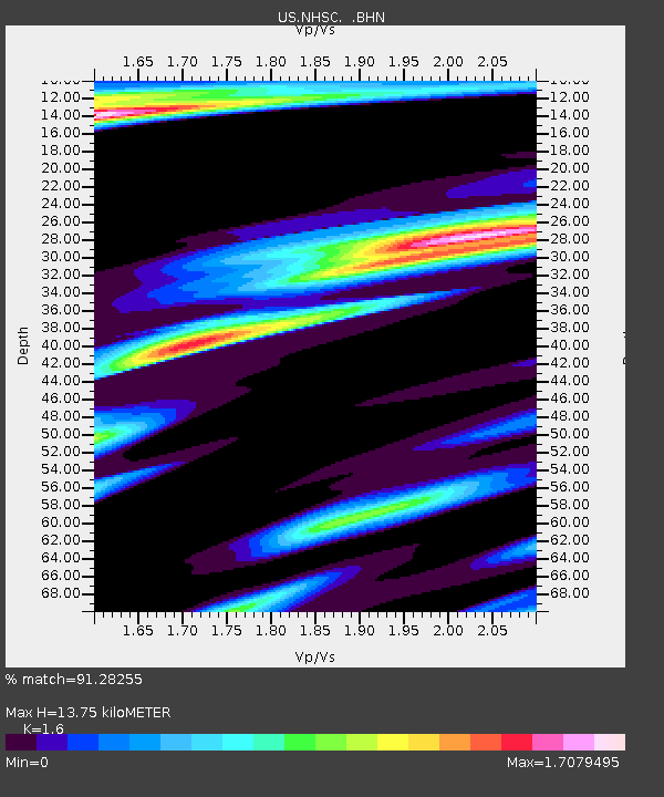
| Estimated Moho Depth: |
13.75 km |
| Estimated Crust Vp/Vs: |
1.60 |
| Assumed Crust Vp: |
6.565 km/s |
| Estimated Crust Vs: |
4.103 km/s |
| Estimated Crust Poisson's Ratio: |
0.18 |
|
| Radial Match: |
91.28255 % |
| Radial Bump: |
361 |
| Transverse Match: |
71.59709 % |
| Transverse Bump: |
400 |
| SOD ConfigId: |
2422 |
| Insert Time: |
2010-03-05 02:07:22.514 +0000 |
| GWidth: |
2.5 |
| Max Bumps: |
400 |
| Tol: |
0.001 |
|

Signal To Noise
| Channel | StoN | STA | LTA |
| US:NHSC: :BHN:20051117T19:35:49.83802Z | 3.9921865 | 7.523068E-6 | 1.884448E-6 |
| US:NHSC: :BHE:20051117T19:35:49.83802Z | 0.6314178 | 2.0546724E-6 | 3.2540615E-6 |
| US:NHSC: :BHZ:20051117T19:35:49.83802Z | 9.411308 | 1.32082005E-5 | 1.4034393E-6 |
| Arrivals |
| Ps | 1.3 SECOND |
| PpPs | 5.1 SECOND |
| PsPs/PpSs | 6.5 SECOND |


