You are here: Home > Network List > US - United States National Seismic Network Stations List
> Station NHSC New Hope, South Carolina, USA > Earthquake Result Viewer
NHSC New Hope, South Carolina, USA - Earthquake Result Viewer
| Earthquake location: |
East Of Kuril Islands |
| Earthquake latitude/longitude: |
46.9/155.2 |
| Earthquake time(UTC): |
2009/01/15 (015) 17:49:39 GMT |
| Earthquake Depth: |
36 km |
| Earthquake Magnitude: |
6.9 MB, 7.5 MS, 7.4 MW, 7.4 MW |
| Earthquake Catalog/Contributor: |
WHDF/NEIC |
|
| Network: |
US United States National Seismic Network |
| Station: |
NHSC New Hope, South Carolina, USA |
| Lat/Lon: |
33.11 N/80.18 W |
| Elevation: |
11 m |
|
| Distance: |
86.1 deg |
| Az: |
43.781 deg |
| Baz: |
325.547 deg |
| Ray Param: |
0.04423322 |
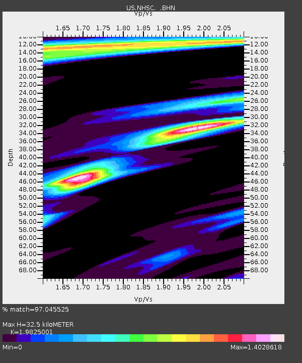
| Estimated Moho Depth: |
32.5 km |
| Estimated Crust Vp/Vs: |
1.98 |
| Assumed Crust Vp: |
6.565 km/s |
| Estimated Crust Vs: |
3.311 km/s |
| Estimated Crust Poisson's Ratio: |
0.33 |
|
| Radial Match: |
97.045525 % |
| Radial Bump: |
379 |
| Transverse Match: |
88.44423 % |
| Transverse Bump: |
400 |
| SOD ConfigId: |
2834 |
| Insert Time: |
2010-03-05 02:07:38.057 +0000 |
| GWidth: |
2.5 |
| Max Bumps: |
400 |
| Tol: |
0.001 |
|

Signal To Noise
| Channel | StoN | STA | LTA |
| US:NHSC: :BHN:20090115T18:01:45.114006Z | 15.924164 | 1.2041206E-5 | 7.561594E-7 |
| US:NHSC: :BHE:20090115T18:01:45.114006Z | 7.032652 | 6.452026E-6 | 9.174385E-7 |
| US:NHSC: :BHZ:20090115T18:01:45.114006Z | 2.548479 | 3.5194294E-6 | 1.380992E-6 |
| Arrivals |
| Ps | 5.0 SECOND |
| PpPs | 14 SECOND |
| PsPs/PpSs | 19 SECOND |


