You are here: Home > Network List > US - United States National Seismic Network Stations List
> Station NHSC New Hope, South Carolina, USA > Earthquake Result Viewer
NHSC New Hope, South Carolina, USA - Earthquake Result Viewer
| Earthquake location: |
East Of Kuril Islands |
| Earthquake latitude/longitude: |
46.2/154.5 |
| Earthquake time(UTC): |
2007/01/13 (013) 04:23:21 GMT |
| Earthquake Depth: |
10 km |
| Earthquake Magnitude: |
7.3 MB, 8.2 MS, 8.1 MW, 7.9 MW |
| Earthquake Catalog/Contributor: |
WHDF/NEIC |
|
| Network: |
US United States National Seismic Network |
| Station: |
NHSC New Hope, South Carolina, USA |
| Lat/Lon: |
33.11 N/80.18 W |
| Elevation: |
11 m |
|
| Distance: |
86.9 deg |
| Az: |
43.318 deg |
| Baz: |
325.439 deg |
| Ray Param: |
0.043744627 |
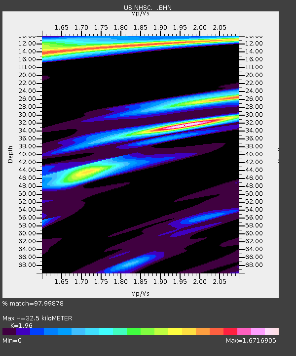
| Estimated Moho Depth: |
32.5 km |
| Estimated Crust Vp/Vs: |
1.96 |
| Assumed Crust Vp: |
6.565 km/s |
| Estimated Crust Vs: |
3.349 km/s |
| Estimated Crust Poisson's Ratio: |
0.32 |
|
| Radial Match: |
97.99878 % |
| Radial Bump: |
331 |
| Transverse Match: |
93.26498 % |
| Transverse Bump: |
400 |
| SOD ConfigId: |
2564 |
| Insert Time: |
2010-03-05 02:07:47.752 +0000 |
| GWidth: |
2.5 |
| Max Bumps: |
400 |
| Tol: |
0.001 |
|

Signal To Noise
| Channel | StoN | STA | LTA |
| US:NHSC: :BHN:20070113T04:35:34.315029Z | 1.5166407 | 1.1809262E-6 | 7.7864604E-7 |
| US:NHSC: :BHE:20070113T04:35:34.315029Z | 1.330913 | 8.5961483E-7 | 6.458836E-7 |
| US:NHSC: :BHZ:20070113T04:35:34.315029Z | 5.7579055 | 1.9900692E-6 | 3.456238E-7 |
| Arrivals |
| Ps | 4.9 SECOND |
| PpPs | 14 SECOND |
| PsPs/PpSs | 19 SECOND |


