You are here: Home > Network List > N4 - Central and EAstern US Network Stations List
> Station F42A Maple Grove Farm, Niagara, WI, USA > Earthquake Result Viewer
F42A Maple Grove Farm, Niagara, WI, USA - Earthquake Result Viewer
| Earthquake location: |
Near Coast Of Ecuador |
| Earthquake latitude/longitude: |
0.6/-80.3 |
| Earthquake time(UTC): |
2016/04/23 (114) 01:24:34 GMT |
| Earthquake Depth: |
10 km |
| Earthquake Magnitude: |
5.8 MWP |
| Earthquake Catalog/Contributor: |
NEIC PDE/NEIC COMCAT |
|
| Network: |
N4 Central and EAstern US Network |
| Station: |
F42A Maple Grove Farm, Niagara, WI, USA |
| Lat/Lon: |
45.76 N/88.13 W |
| Elevation: |
358 m |
|
| Distance: |
45.5 deg |
| Az: |
352.281 deg |
| Baz: |
168.94 deg |
| Ray Param: |
0.07123657 |
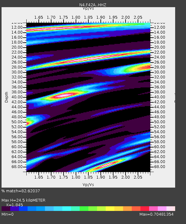
| Estimated Moho Depth: |
24.5 km |
| Estimated Crust Vp/Vs: |
1.85 |
| Assumed Crust Vp: |
6.41 km/s |
| Estimated Crust Vs: |
3.474 km/s |
| Estimated Crust Poisson's Ratio: |
0.29 |
|
| Radial Match: |
82.62037 % |
| Radial Bump: |
346 |
| Transverse Match: |
73.59299 % |
| Transverse Bump: |
400 |
| SOD ConfigId: |
7422571 |
| Insert Time: |
2019-04-22 10:51:57.576 +0000 |
| GWidth: |
2.5 |
| Max Bumps: |
400 |
| Tol: |
0.001 |
|

Signal To Noise
| Channel | StoN | STA | LTA |
| N4:F42A: :HHZ:20160423T01:32:22.359985Z | 4.643717 | 8.0852715E-7 | 1.7411207E-7 |
| N4:F42A: :HHN:20160423T01:32:22.359985Z | 3.5976803 | 4.901338E-7 | 1.3623607E-7 |
| N4:F42A: :HHE:20160423T01:32:22.359985Z | 1.7736067 | 1.9475895E-7 | 1.09809555E-7 |
| Arrivals |
| Ps | 3.4 SECOND |
| PpPs | 10 SECOND |
| PsPs/PpSs | 14 SECOND |


