You are here: Home > Network List > N4 - Central and EAstern US Network Stations List
> Station T47A Sharon Grove, KY, USA > Earthquake Result Viewer
T47A Sharon Grove, KY, USA - Earthquake Result Viewer
| Earthquake location: |
Near Coast Of Ecuador |
| Earthquake latitude/longitude: |
0.6/-80.3 |
| Earthquake time(UTC): |
2016/04/23 (114) 01:24:34 GMT |
| Earthquake Depth: |
10 km |
| Earthquake Magnitude: |
5.8 MWP |
| Earthquake Catalog/Contributor: |
NEIC PDE/NEIC COMCAT |
|
| Network: |
N4 Central and EAstern US Network |
| Station: |
T47A Sharon Grove, KY, USA |
| Lat/Lon: |
36.99 N/87.11 W |
| Elevation: |
217 m |
|
| Distance: |
36.8 deg |
| Az: |
350.836 deg |
| Baz: |
168.528 deg |
| Ray Param: |
0.076507926 |
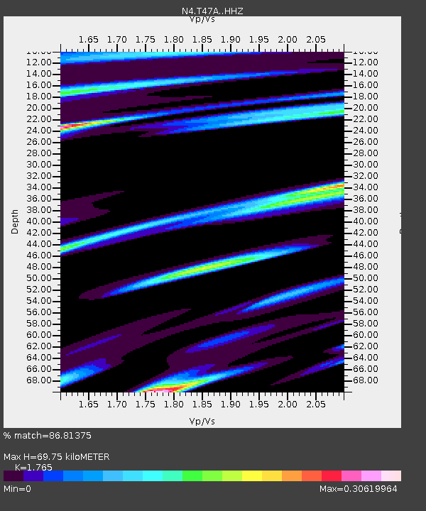
| Estimated Moho Depth: |
69.75 km |
| Estimated Crust Vp/Vs: |
1.76 |
| Assumed Crust Vp: |
6.444 km/s |
| Estimated Crust Vs: |
3.651 km/s |
| Estimated Crust Poisson's Ratio: |
0.26 |
|
| Radial Match: |
86.81375 % |
| Radial Bump: |
297 |
| Transverse Match: |
75.59283 % |
| Transverse Bump: |
400 |
| SOD ConfigId: |
7422571 |
| Insert Time: |
2019-04-22 10:52:56.312 +0000 |
| GWidth: |
2.5 |
| Max Bumps: |
400 |
| Tol: |
0.001 |
|

Signal To Noise
| Channel | StoN | STA | LTA |
| N4:T47A: :HHZ:20160423T01:31:10.529999Z | 5.76936 | 6.770583E-7 | 1.1735415E-7 |
| N4:T47A: :HHN:20160423T01:31:10.529999Z | 3.888358 | 4.4888952E-7 | 1.1544449E-7 |
| N4:T47A: :HHE:20160423T01:31:10.529999Z | 0.87567747 | 9.4900656E-8 | 1.0837399E-7 |
| Arrivals |
| Ps | 8.9 SECOND |
| PpPs | 28 SECOND |
| PsPs/PpSs | 37 SECOND |


