You are here: Home > Network List > N4 - Central and EAstern US Network Stations List
> Station Y49A Blount Mountain, AL, USA > Earthquake Result Viewer
Y49A Blount Mountain, AL, USA - Earthquake Result Viewer
| Earthquake location: |
Near Coast Of Ecuador |
| Earthquake latitude/longitude: |
0.6/-80.3 |
| Earthquake time(UTC): |
2016/04/23 (114) 01:24:34 GMT |
| Earthquake Depth: |
10 km |
| Earthquake Magnitude: |
5.8 MWP |
| Earthquake Catalog/Contributor: |
NEIC PDE/NEIC COMCAT |
|
| Network: |
N4 Central and EAstern US Network |
| Station: |
Y49A Blount Mountain, AL, USA |
| Lat/Lon: |
33.86 N/86.41 W |
| Elevation: |
362 m |
|
| Distance: |
33.6 deg |
| Az: |
350.737 deg |
| Baz: |
168.847 deg |
| Ray Param: |
0.07814162 |
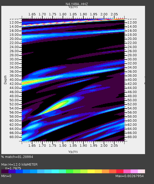
| Estimated Moho Depth: |
12.0 km |
| Estimated Crust Vp/Vs: |
1.77 |
| Assumed Crust Vp: |
6.565 km/s |
| Estimated Crust Vs: |
3.714 km/s |
| Estimated Crust Poisson's Ratio: |
0.26 |
|
| Radial Match: |
81.28994 % |
| Radial Bump: |
316 |
| Transverse Match: |
55.75806 % |
| Transverse Bump: |
400 |
| SOD ConfigId: |
7422571 |
| Insert Time: |
2019-04-22 10:53:14.624 +0000 |
| GWidth: |
2.5 |
| Max Bumps: |
400 |
| Tol: |
0.001 |
|

Signal To Noise
| Channel | StoN | STA | LTA |
| N4:Y49A: :HHZ:20160423T01:30:43.250Z | 2.8435051 | 6.439527E-7 | 2.264644E-7 |
| N4:Y49A: :HHN:20160423T01:30:43.250Z | 1.5790114 | 3.2875877E-7 | 2.0820545E-7 |
| N4:Y49A: :HHE:20160423T01:30:43.250Z | 1.0937915 | 1.703253E-7 | 1.5572006E-7 |
| Arrivals |
| Ps | 1.5 SECOND |
| PpPs | 4.7 SECOND |
| PsPs/PpSs | 6.2 SECOND |


