You are here: Home > Network List > N4 - Central and EAstern US Network Stations List
> Station Z51A Franklin, GA, USA > Earthquake Result Viewer
Z51A Franklin, GA, USA - Earthquake Result Viewer
| Earthquake location: |
Near Coast Of Ecuador |
| Earthquake latitude/longitude: |
0.6/-80.3 |
| Earthquake time(UTC): |
2016/04/23 (114) 01:24:34 GMT |
| Earthquake Depth: |
10 km |
| Earthquake Magnitude: |
5.8 MWP |
| Earthquake Catalog/Contributor: |
NEIC PDE/NEIC COMCAT |
|
| Network: |
N4 Central and EAstern US Network |
| Station: |
Z51A Franklin, GA, USA |
| Lat/Lon: |
33.32 N/85.17 W |
| Elevation: |
249 m |
|
| Distance: |
32.9 deg |
| Az: |
352.419 deg |
| Baz: |
170.936 deg |
| Ray Param: |
0.07846859 |
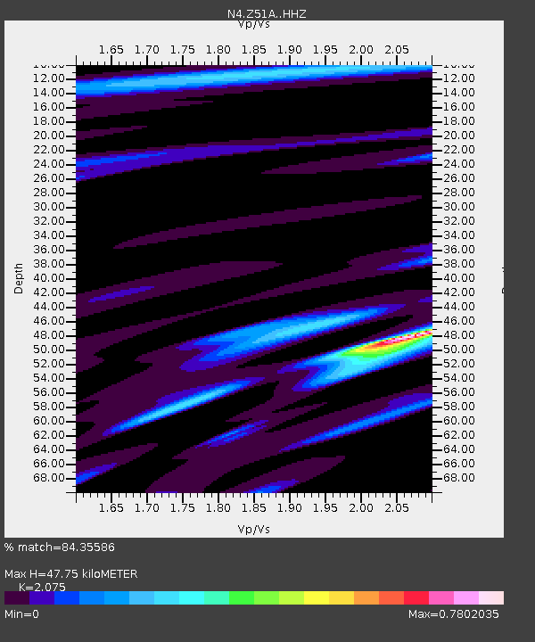
| Estimated Moho Depth: |
47.75 km |
| Estimated Crust Vp/Vs: |
2.08 |
| Assumed Crust Vp: |
6.719 km/s |
| Estimated Crust Vs: |
3.238 km/s |
| Estimated Crust Poisson's Ratio: |
0.35 |
|
| Radial Match: |
84.35586 % |
| Radial Bump: |
220 |
| Transverse Match: |
55.391552 % |
| Transverse Bump: |
400 |
| SOD ConfigId: |
7422571 |
| Insert Time: |
2019-04-22 10:53:19.122 +0000 |
| GWidth: |
2.5 |
| Max Bumps: |
400 |
| Tol: |
0.001 |
|

Signal To Noise
| Channel | StoN | STA | LTA |
| N4:Z51A: :HHZ:20160423T01:30:37.049988Z | 5.338985 | 7.9757854E-7 | 1.4938766E-7 |
| N4:Z51A: :HHN:20160423T01:30:37.049988Z | 4.40888 | 5.5072013E-7 | 1.2491155E-7 |
| N4:Z51A: :HHE:20160423T01:30:37.049988Z | 1.3019904 | 1.4722897E-7 | 1.1307991E-7 |
| Arrivals |
| Ps | 8.2 SECOND |
| PpPs | 20 SECOND |
| PsPs/PpSs | 29 SECOND |


