You are here: Home > Network List > US - United States National Seismic Network Stations List
> Station WMOK Wichita Mountains, Oklahoma, USA > Earthquake Result Viewer
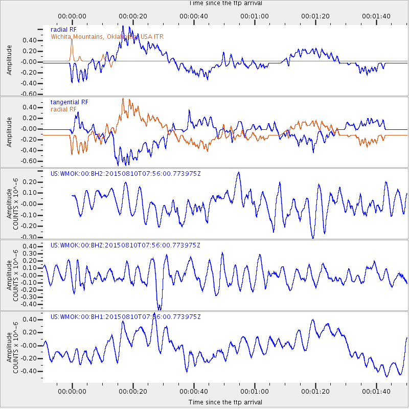
WMOK Wichita Mountains, Oklahoma, USA - Earthquake Result Viewer
*The percent match for this event was below the threshold and hence no stack was calculated.
| Earthquake location: |
Tonga Islands |
| Earthquake latitude/longitude: |
-19.6/-174.8 |
| Earthquake time(UTC): |
2015/08/10 (222) 07:43:38 GMT |
| Earthquake Depth: |
57 km |
| Earthquake Magnitude: |
5.6 MB |
| Earthquake Catalog/Contributor: |
NEIC PDE/NEIC ALERT |
|
| Network: |
US United States National Seismic Network |
| Station: |
WMOK Wichita Mountains, Oklahoma, USA |
| Lat/Lon: |
34.74 N/98.78 W |
| Elevation: |
486 m |
|
| Distance: |
90.1 deg |
| Az: |
53.052 deg |
| Baz: |
246.168 deg |
| Ray Param: |
$rayparam |
*The percent match for this event was below the threshold and hence was not used in the summary stack. |
|
| Radial Match: |
51.050583 % |
| Radial Bump: |
400 |
| Transverse Match: |
52.157555 % |
| Transverse Bump: |
400 |
| SOD ConfigId: |
1085051 |
| Insert Time: |
2015-08-24 08:17:57.545 +0000 |
| GWidth: |
2.5 |
| Max Bumps: |
400 |
| Tol: |
0.001 |
|
Signal To Noise
| Channel | StoN | STA | LTA |
| US:WMOK:00:BHZ:20150810T07:56:00.773975Z | 1.6055338 | 1.44012E-7 | 8.9697274E-8 |
| US:WMOK:00:BH1:20150810T07:56:00.773975Z | 2.1023805 | 2.5869474E-7 | 1.2304848E-7 |
| US:WMOK:00:BH2:20150810T07:56:00.773975Z | 1.108403 | 1.0011795E-7 | 9.03263E-8 |
| Arrivals |
| Ps | |
| PpPs | |
| PsPs/PpSs | |


