You are here: Home > Network List > TA - USArray Transportable Network (new EarthScope stations) Stations List
> Station 435B Jarrell, TX, USA > Earthquake Result Viewer
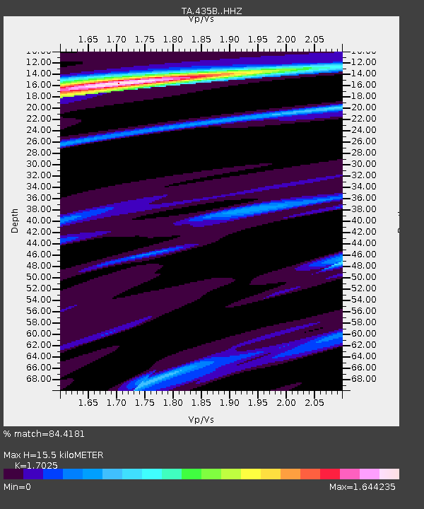
435B Jarrell, TX, USA - Earthquake Result Viewer
| Earthquake location: |
Near Coast Of Ecuador |
| Earthquake latitude/longitude: |
0.6/-80.3 |
| Earthquake time(UTC): |
2016/04/23 (114) 01:24:34 GMT |
| Earthquake Depth: |
10 km |
| Earthquake Magnitude: |
5.8 MWP |
| Earthquake Catalog/Contributor: |
NEIC PDE/NEIC COMCAT |
|
| Network: |
TA USArray Transportable Network (new EarthScope stations) |
| Station: |
435B Jarrell, TX, USA |
| Lat/Lon: |
30.78 N/97.58 W |
| Elevation: |
248 m |
|
| Distance: |
34.2 deg |
| Az: |
332.905 deg |
| Baz: |
148.048 deg |
| Ray Param: |
0.07784714 |
| Estimated Moho Depth: |
15.5 km |
| Estimated Crust Vp/Vs: |
1.70 |
| Assumed Crust Vp: |
6.347 km/s |
| Estimated Crust Vs: |
3.728 km/s |
| Estimated Crust Poisson's Ratio: |
0.24 |
|
| Radial Match: |
84.4181 % |
| Radial Bump: |
227 |
| Transverse Match: |
73.41861 % |
| Transverse Bump: |
400 |
| SOD ConfigId: |
7422571 |
| Insert Time: |
2019-04-22 10:55:15.035 +0000 |
| GWidth: |
2.5 |
| Max Bumps: |
400 |
| Tol: |
0.001 |
|

Signal To Noise
| Channel | StoN | STA | LTA |
| TA:435B: :HHZ:20160423T01:30:48.850006Z | 7.99575 | 9.560094E-7 | 1.195647E-7 |
| TA:435B: :HHN:20160423T01:30:48.850006Z | 6.816583 | 5.835033E-7 | 8.560056E-8 |
| TA:435B: :HHE:20160423T01:30:48.850006Z | 2.4082618 | 2.9887133E-7 | 1.241025E-7 |
| Arrivals |
| Ps | 1.9 SECOND |
| PpPs | 6.1 SECOND |
| PsPs/PpSs | 8.0 SECOND |


