You are here: Home > Network List > TA - USArray Transportable Network (new EarthScope stations) Stations List
> Station 833A Chaparral WMA, Artesia Wells, TX, USA > Earthquake Result Viewer
833A Chaparral WMA, Artesia Wells, TX, USA - Earthquake Result Viewer
| Earthquake location: |
Near Coast Of Ecuador |
| Earthquake latitude/longitude: |
0.6/-80.3 |
| Earthquake time(UTC): |
2016/04/23 (114) 01:24:34 GMT |
| Earthquake Depth: |
10 km |
| Earthquake Magnitude: |
5.8 MWP |
| Earthquake Catalog/Contributor: |
NEIC PDE/NEIC COMCAT |
|
| Network: |
TA USArray Transportable Network (new EarthScope stations) |
| Station: |
833A Chaparral WMA, Artesia Wells, TX, USA |
| Lat/Lon: |
28.32 N/99.39 W |
| Elevation: |
171 m |
|
| Distance: |
33.1 deg |
| Az: |
328.059 deg |
| Baz: |
143.126 deg |
| Ray Param: |
0.07836874 |
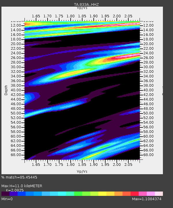
| Estimated Moho Depth: |
11.0 km |
| Estimated Crust Vp/Vs: |
2.08 |
| Assumed Crust Vp: |
6.347 km/s |
| Estimated Crust Vs: |
3.048 km/s |
| Estimated Crust Poisson's Ratio: |
0.35 |
|
| Radial Match: |
85.45445 % |
| Radial Bump: |
256 |
| Transverse Match: |
75.03435 % |
| Transverse Bump: |
395 |
| SOD ConfigId: |
7422571 |
| Insert Time: |
2019-04-22 10:55:16.881 +0000 |
| GWidth: |
2.5 |
| Max Bumps: |
400 |
| Tol: |
0.001 |
|
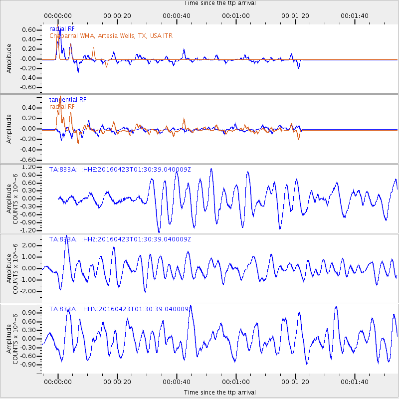
Signal To Noise
| Channel | StoN | STA | LTA |
| TA:833A: :HHZ:20160423T01:30:39.040009Z | 14.340444 | 1.4069657E-6 | 9.811173E-8 |
| TA:833A: :HHN:20160423T01:30:39.040009Z | 6.2120442 | 6.0759703E-7 | 9.780952E-8 |
| TA:833A: :HHE:20160423T01:30:39.040009Z | 5.1414237 | 6.5554786E-7 | 1.2750317E-7 |
| Arrivals |
| Ps | 2.0 SECOND |
| PpPs | 5.0 SECOND |
| PsPs/PpSs | 7.0 SECOND |


