You are here: Home > Network List > TA - USArray Transportable Network (new EarthScope stations) Stations List
> Station J01E Myrtle Point, OR, USA > Earthquake Result Viewer
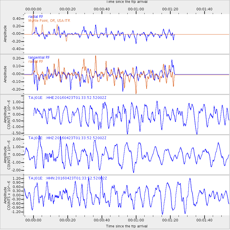
J01E Myrtle Point, OR, USA - Earthquake Result Viewer
*The percent match for this event was below the threshold and hence no stack was calculated.
| Earthquake location: |
Near Coast Of Ecuador |
| Earthquake latitude/longitude: |
0.6/-80.3 |
| Earthquake time(UTC): |
2016/04/23 (114) 01:24:34 GMT |
| Earthquake Depth: |
10 km |
| Earthquake Magnitude: |
5.8 MWP |
| Earthquake Catalog/Contributor: |
NEIC PDE/NEIC COMCAT |
|
| Network: |
TA USArray Transportable Network (new EarthScope stations) |
| Station: |
J01E Myrtle Point, OR, USA |
| Lat/Lon: |
43.16 N/123.93 W |
| Elevation: |
128 m |
|
| Distance: |
57.6 deg |
| Az: |
323.232 deg |
| Baz: |
125.114 deg |
| Ray Param: |
$rayparam |
*The percent match for this event was below the threshold and hence was not used in the summary stack. |
|
| Radial Match: |
61.33217 % |
| Radial Bump: |
400 |
| Transverse Match: |
69.486946 % |
| Transverse Bump: |
400 |
| SOD ConfigId: |
7422571 |
| Insert Time: |
2019-04-22 10:55:36.337 +0000 |
| GWidth: |
2.5 |
| Max Bumps: |
400 |
| Tol: |
0.001 |
|
Signal To Noise
| Channel | StoN | STA | LTA |
| TA:J01E: :HHZ:20160423T01:33:52.52002Z | 3.309479 | 1.2471792E-6 | 3.768506E-7 |
| TA:J01E: :HHN:20160423T01:33:52.52002Z | 1.3318708 | 5.791034E-7 | 4.3480446E-7 |
| TA:J01E: :HHE:20160423T01:33:52.52002Z | 1.5306375 | 6.113179E-7 | 3.9938777E-7 |
| Arrivals |
| Ps | |
| PpPs | |
| PsPs/PpSs | |


