You are here: Home > Network List > TA - USArray Transportable Network (new EarthScope stations) Stations List
> Station J26L Joseph Creek, AK, USA > Earthquake Result Viewer
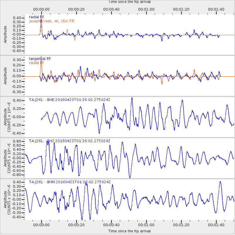
J26L Joseph Creek, AK, USA - Earthquake Result Viewer
*The percent match for this event was below the threshold and hence no stack was calculated.
| Earthquake location: |
Near Coast Of Ecuador |
| Earthquake latitude/longitude: |
0.6/-80.3 |
| Earthquake time(UTC): |
2016/04/23 (114) 01:24:34 GMT |
| Earthquake Depth: |
10 km |
| Earthquake Magnitude: |
5.8 MWP |
| Earthquake Catalog/Contributor: |
NEIC PDE/NEIC COMCAT |
|
| Network: |
TA USArray Transportable Network (new EarthScope stations) |
| Station: |
J26L Joseph Creek, AK, USA |
| Lat/Lon: |
64.50 N/143.56 W |
| Elevation: |
1144 m |
|
| Distance: |
78.2 deg |
| Az: |
336.736 deg |
| Baz: |
114.154 deg |
| Ray Param: |
$rayparam |
*The percent match for this event was below the threshold and hence was not used in the summary stack. |
|
| Radial Match: |
71.3422 % |
| Radial Bump: |
296 |
| Transverse Match: |
59.193237 % |
| Transverse Bump: |
344 |
| SOD ConfigId: |
7422571 |
| Insert Time: |
2019-04-22 10:55:39.512 +0000 |
| GWidth: |
2.5 |
| Max Bumps: |
400 |
| Tol: |
0.001 |
|
Signal To Noise
| Channel | StoN | STA | LTA |
| TA:J26L: :BHZ:20160423T01:36:02.275024Z | 4.0842786 | 5.302392E-7 | 1.2982446E-7 |
| TA:J26L: :BHN:20160423T01:36:02.275024Z | 0.5242328 | 7.6106154E-8 | 1.4517626E-7 |
| TA:J26L: :BHE:20160423T01:36:02.275024Z | 1.5151725 | 1.7757328E-7 | 1.1719675E-7 |
| Arrivals |
| Ps | |
| PpPs | |
| PsPs/PpSs | |


