You are here: Home > Network List > XD14 - Illuminating the architecture of the greater Mount St. Helens magmatic systems f Stations List
> Station MI05 "Mount St Helens, WA" > Earthquake Result Viewer
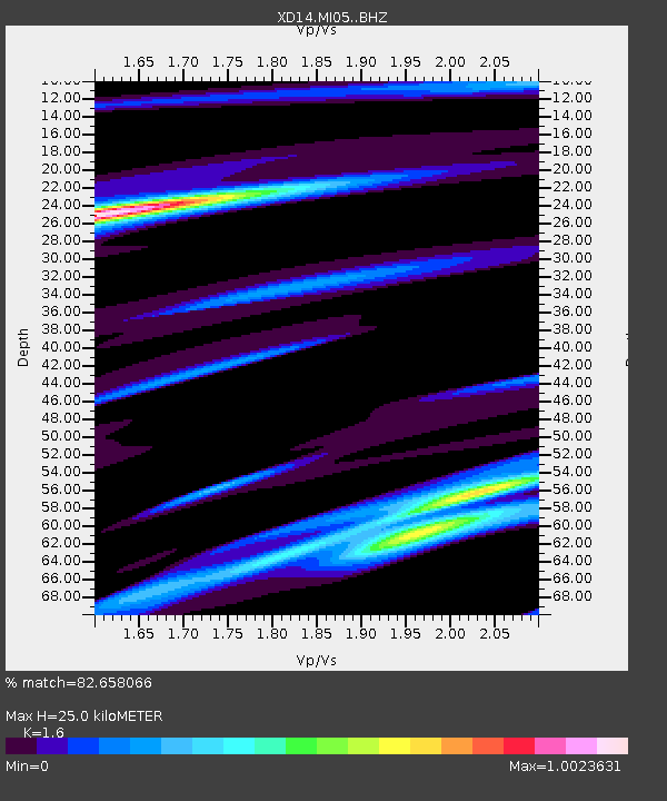
MI05 "Mount St Helens, WA" - Earthquake Result Viewer
| Earthquake location: |
Near Coast Of Ecuador |
| Earthquake latitude/longitude: |
0.6/-80.3 |
| Earthquake time(UTC): |
2016/04/23 (114) 01:24:34 GMT |
| Earthquake Depth: |
10 km |
| Earthquake Magnitude: |
5.8 MWP |
| Earthquake Catalog/Contributor: |
NEIC PDE/NEIC COMCAT |
|
| Network: |
XD Illuminating the architecture of the greater Mount St. Helens magmatic systems f |
| Station: |
MI05 "Mount St Helens, WA" |
| Lat/Lon: |
46.23 N/122.29 W |
| Elevation: |
1255 m |
|
| Distance: |
58.5 deg |
| Az: |
326.957 deg |
| Baz: |
128.238 deg |
| Ray Param: |
0.06283287 |
| Estimated Moho Depth: |
25.0 km |
| Estimated Crust Vp/Vs: |
1.60 |
| Assumed Crust Vp: |
6.566 km/s |
| Estimated Crust Vs: |
4.104 km/s |
| Estimated Crust Poisson's Ratio: |
0.18 |
|
| Radial Match: |
82.658066 % |
| Radial Bump: |
266 |
| Transverse Match: |
63.205063 % |
| Transverse Bump: |
379 |
| SOD ConfigId: |
7422571 |
| Insert Time: |
2019-04-22 10:57:48.717 +0000 |
| GWidth: |
2.5 |
| Max Bumps: |
400 |
| Tol: |
0.001 |
|

Signal To Noise
| Channel | StoN | STA | LTA |
| XD:MI05: :BHZ:20160423T01:33:58.784973Z | 2.0306764 | 6.404202E-7 | 3.1537286E-7 |
| XD:MI05: :BHN:20160423T01:33:58.784973Z | 0.97547245 | 2.260185E-7 | 2.3170156E-7 |
| XD:MI05: :BHE:20160423T01:33:58.784973Z | 0.80753094 | 3.524513E-7 | 4.364555E-7 |
| Arrivals |
| Ps | 2.4 SECOND |
| PpPs | 9.4 SECOND |
| PsPs/PpSs | 12 SECOND |


