You are here: Home > Network List > US - United States National Seismic Network Stations List
> Station MSO Missoula, Montana, USA > Earthquake Result Viewer
MSO Missoula, Montana, USA - Earthquake Result Viewer

| Earthquake location: |
Primor'ye, Russia |
| Earthquake latitude/longitude: |
47.2/139.2 |
| Earthquake time(UTC): |
2003/07/27 (208) 06:25:31 GMT |
| Earthquake Depth: |
470 km |
| Earthquake Magnitude: |
6.3 MB, 6.8 MW, 6.8 MW |
| Earthquake Catalog/Contributor: |
WHDF/NEIC |
|
| Network: |
US United States National Seismic Network |
| Station: |
MSO Missoula, Montana, USA |
| Lat/Lon: |
46.83 N/113.94 W |
| Elevation: |
1264 m |
|
| Distance: |
66.7 deg |
| Az: |
45.703 deg |
| Baz: |
314.647 deg |
| Ray Param: |
0.05585471 |
| Estimated Moho Depth: |
15.75 km |
| Estimated Crust Vp/Vs: |
1.81 |
| Assumed Crust Vp: |
6.353 km/s |
| Estimated Crust Vs: |
3.51 km/s |
| Estimated Crust Poisson's Ratio: |
0.28 |
|
| Radial Match: |
93.23159 % |
| Radial Bump: |
400 |
| Transverse Match: |
86.93418 % |
| Transverse Bump: |
400 |
| SOD ConfigId: |
110177 |
| Insert Time: |
2010-03-05 02:09:34.637 +0000 |
| GWidth: |
2.5 |
| Max Bumps: |
400 |
| Tol: |
0.001 |
|
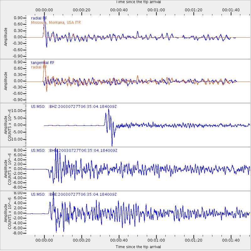
Signal To Noise
| Channel | StoN | STA | LTA |
| US:MSO: :BHN:20030727T06:35:04.184009Z | 59.165028 | 1.6691888E-6 | 2.8212423E-8 |
| US:MSO: :BHE:20030727T06:35:04.184009Z | 61.932983 | 2.3541386E-6 | 3.8011066E-8 |
| US:MSO: :BHZ:20030727T06:35:04.184009Z | 92.614174 | 4.1404055E-6 | 4.4705956E-8 |
| Arrivals |
| Ps | 2.1 SECOND |
| PpPs | 6.7 SECOND |
| PsPs/PpSs | 8.8 SECOND |


