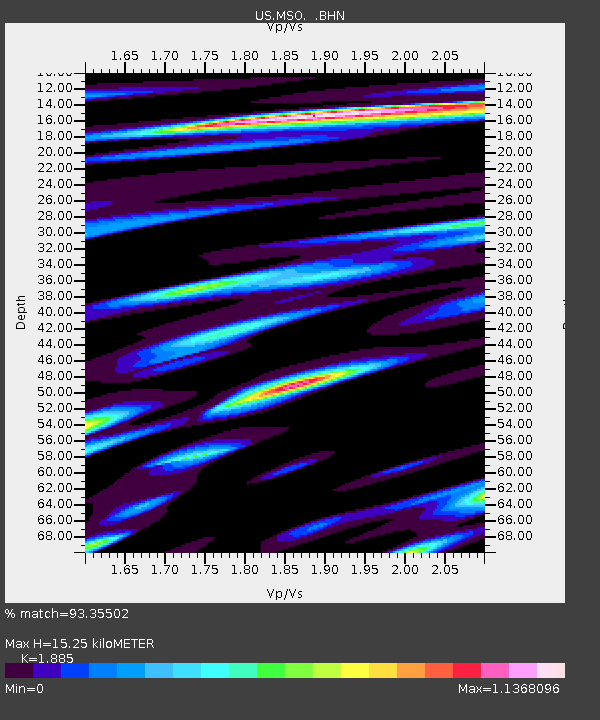
MSO Missoula, Montana, USA - Earthquake Result Viewer

Earthquake location: Near S. Coast Of Honshu, Japan
Earthquake latitude/longitude: 33.2/137.2
Earthquake time(UTC): 2004/09/06 (250) 23:29:35 GMT
Earthquake Depth: 10 km
Earthquake Magnitude: 6.4 MB, 6.3 MS, 6.7 MW, 6.5 MW
Earthquake Catalog/Contributor: WHDF/NEIC
Network: US United States National Seismic Network
Station: MSO Missoula, Montana, USA
Lat/Lon: 46.83 N/113.94 W
Elevation: 1264 m
Distance: 77.9 deg
Az: 41.663 deg
Baz: 305.738 deg
Ray Param: 0.050041072
Estimated Moho Depth: 15.25 km
Estimated Crust Vp/Vs: 1.88
Assumed Crust Vp: 6.353 km/s
Estimated Crust Vs: 3.37 km/s
Estimated Crust Poisson's Ratio: 0.30
Radial Match: 93.35502 %
Radial Bump: 400
Transverse Match: 85.120224 %
Transverse Bump: 400
SOD ConfigId: 110177
Insert Time: 2010-03-05 02:09:47.555 +0000
GWidth: 2.5
Max Bumps: 400
Tol: 0.001

Signal To Noise

ChannelStoNSTALTA
US:MSO: :BHN:20040906T23:41:01.371006Z3.3837362.3404102E-76.9166454E-8
US:MSO: :BHE:20040906T23:41:01.371006Z5.9941434.284944E-77.1485516E-8
US:MSO: :BHZ:20040906T23:41:01.371006Z16.0341876.4987273E-74.0530445E-8
Arrivals
Ps2.2 SECOND
PpPs6.7 SECOND
PsPs/PpSs8.9 SECOND