You are here: Home > Network List > YT07 - POLENET Stations List
> Station MPAT MPAT > Earthquake Result Viewer
MPAT MPAT - Earthquake Result Viewer
| Earthquake location: |
South Sandwich Islands Region |
| Earthquake latitude/longitude: |
-59.3/-27.0 |
| Earthquake time(UTC): |
2016/04/24 (115) 08:38:00 GMT |
| Earthquake Depth: |
10 km |
| Earthquake Magnitude: |
5.5 MB |
| Earthquake Catalog/Contributor: |
NEIC PDE/NEIC COMCAT |
|
| Network: |
YT POLENET |
| Station: |
MPAT MPAT |
| Lat/Lon: |
78.03 S/155.02 W |
| Elevation: |
540 m |
|
| Distance: |
39.3 deg |
| Az: |
195.052 deg |
| Baz: |
140.393 deg |
| Ray Param: |
0.07506899 |
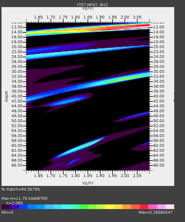
| Estimated Moho Depth: |
11.75 km |
| Estimated Crust Vp/Vs: |
2.10 |
| Assumed Crust Vp: |
6.43 km/s |
| Estimated Crust Vs: |
3.069 km/s |
| Estimated Crust Poisson's Ratio: |
0.35 |
|
| Radial Match: |
94.58795 % |
| Radial Bump: |
271 |
| Transverse Match: |
74.55958 % |
| Transverse Bump: |
400 |
| SOD ConfigId: |
7422571 |
| Insert Time: |
2019-04-22 11:03:14.947 +0000 |
| GWidth: |
2.5 |
| Max Bumps: |
400 |
| Tol: |
0.001 |
|

Signal To Noise
| Channel | StoN | STA | LTA |
| YT:MPAT: :BHZ:20160424T08:44:58.200004Z | 1.7532834 | 3.8630205E-7 | 2.2033063E-7 |
| YT:MPAT: :BHN:20160424T08:44:58.200004Z | 1.5809677 | 2.2633125E-7 | 1.4315995E-7 |
| YT:MPAT: :BHE:20160424T08:44:58.200004Z | 4.24715 | 2.7075302E-7 | 6.374935E-8 |
| Arrivals |
| Ps | 2.1 SECOND |
| PpPs | 5.3 SECOND |
| PsPs/PpSs | 7.5 SECOND |


