You are here: Home > Network List > CI - Caltech Regional Seismic Network Stations List
> Station MPP McPhearson Peak > Earthquake Result Viewer
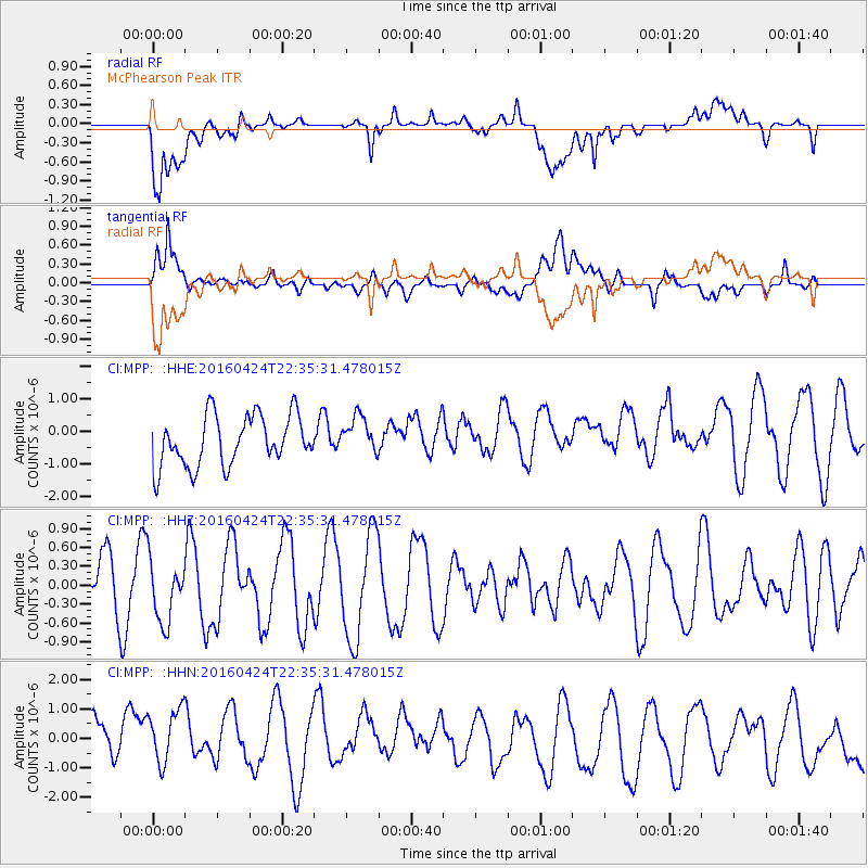
MPP McPhearson Peak - Earthquake Result Viewer
*The percent match for this event was below the threshold and hence no stack was calculated.
| Earthquake location: |
Tonga Islands |
| Earthquake latitude/longitude: |
-17.7/-173.2 |
| Earthquake time(UTC): |
2016/04/24 (115) 22:24:36 GMT |
| Earthquake Depth: |
27 km |
| Earthquake Magnitude: |
5.7 MWW, 5.6 MWB, 5.7 MWC |
| Earthquake Catalog/Contributor: |
NEIC PDE/NEIC COMCAT |
|
| Network: |
CI Caltech Regional Seismic Network |
| Station: |
MPP McPhearson Peak |
| Lat/Lon: |
34.89 N/119.81 W |
| Elevation: |
1739 m |
|
| Distance: |
72.8 deg |
| Az: |
43.684 deg |
| Baz: |
233.217 deg |
| Ray Param: |
$rayparam |
*The percent match for this event was below the threshold and hence was not used in the summary stack. |
|
| Radial Match: |
50.48235 % |
| Radial Bump: |
400 |
| Transverse Match: |
53.465702 % |
| Transverse Bump: |
400 |
| SOD ConfigId: |
7422571 |
| Insert Time: |
2019-04-22 11:06:04.451 +0000 |
| GWidth: |
2.5 |
| Max Bumps: |
400 |
| Tol: |
0.001 |
|
Signal To Noise
| Channel | StoN | STA | LTA |
| CI:MPP: :HHZ:20160424T22:35:31.478015Z | 1.2991642 | 5.034835E-7 | 3.8754413E-7 |
| CI:MPP: :HHN:20160424T22:35:31.478015Z | 1.0772159 | 1.4897354E-6 | 1.3829497E-6 |
| CI:MPP: :HHE:20160424T22:35:31.478015Z | 0.74324584 | 5.762509E-7 | 7.753166E-7 |
| Arrivals |
| Ps | |
| PpPs | |
| PsPs/PpSs | |


