You are here: Home > Network List > TA - USArray Transportable Network (new EarthScope stations) Stations List
> Station I23K Minto, Yukon-Koyukuk, AK, USA > Earthquake Result Viewer
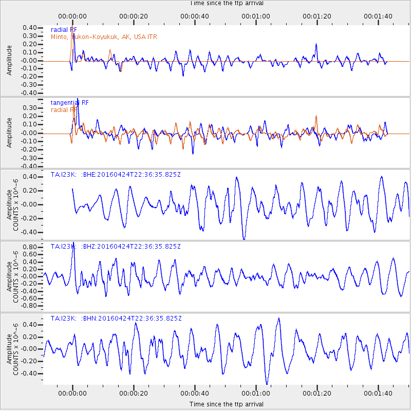
I23K Minto, Yukon-Koyukuk, AK, USA - Earthquake Result Viewer
*The percent match for this event was below the threshold and hence no stack was calculated.
| Earthquake location: |
Tonga Islands |
| Earthquake latitude/longitude: |
-17.7/-173.2 |
| Earthquake time(UTC): |
2016/04/24 (115) 22:24:36 GMT |
| Earthquake Depth: |
27 km |
| Earthquake Magnitude: |
5.7 MWW, 5.6 MWB, 5.7 MWC |
| Earthquake Catalog/Contributor: |
NEIC PDE/NEIC COMCAT |
|
| Network: |
TA USArray Transportable Network (new EarthScope stations) |
| Station: |
I23K Minto, Yukon-Koyukuk, AK, USA |
| Lat/Lon: |
65.15 N/149.36 W |
| Elevation: |
149 m |
|
| Distance: |
84.6 deg |
| Az: |
9.881 deg |
| Baz: |
202.772 deg |
| Ray Param: |
$rayparam |
*The percent match for this event was below the threshold and hence was not used in the summary stack. |
|
| Radial Match: |
47.165623 % |
| Radial Bump: |
400 |
| Transverse Match: |
52.205196 % |
| Transverse Bump: |
350 |
| SOD ConfigId: |
7422571 |
| Insert Time: |
2019-04-22 11:09:29.294 +0000 |
| GWidth: |
2.5 |
| Max Bumps: |
400 |
| Tol: |
0.001 |
|
Signal To Noise
| Channel | StoN | STA | LTA |
| TA:I23K: :BHZ:20160424T22:36:35.825Z | 3.20963 | 3.7587418E-7 | 1.1710826E-7 |
| TA:I23K: :BHN:20160424T22:36:35.825Z | 1.0891885 | 1.4130075E-7 | 1.297303E-7 |
| TA:I23K: :BHE:20160424T22:36:35.825Z | 0.6651292 | 8.8523265E-8 | 1.3309183E-7 |
| Arrivals |
| Ps | |
| PpPs | |
| PsPs/PpSs | |


