You are here: Home > Network List > US - United States National Seismic Network Stations List
> Station MSO Missoula, Montana, USA > Earthquake Result Viewer
MSO Missoula, Montana, USA - Earthquake Result Viewer

| Earthquake location: |
New Ireland Region, P.N.G. |
| Earthquake latitude/longitude: |
-4.5/153.5 |
| Earthquake time(UTC): |
2005/09/09 (252) 07:26:43 GMT |
| Earthquake Depth: |
90 km |
| Earthquake Magnitude: |
6.3 MB, 7.7 MW, 7.5 MW |
| Earthquake Catalog/Contributor: |
WHDF/NEIC |
|
| Network: |
US United States National Seismic Network |
| Station: |
MSO Missoula, Montana, USA |
| Lat/Lon: |
46.83 N/113.94 W |
| Elevation: |
1264 m |
|
| Distance: |
95.1 deg |
| Az: |
43.519 deg |
| Baz: |
268.776 deg |
| Ray Param: |
0.040822905 |
| Estimated Moho Depth: |
64.75 km |
| Estimated Crust Vp/Vs: |
1.89 |
| Assumed Crust Vp: |
6.353 km/s |
| Estimated Crust Vs: |
3.353 km/s |
| Estimated Crust Poisson's Ratio: |
0.31 |
|
| Radial Match: |
93.815 % |
| Radial Bump: |
400 |
| Transverse Match: |
73.084045 % |
| Transverse Bump: |
400 |
| SOD ConfigId: |
2669 |
| Insert Time: |
2010-03-05 02:10:27.741 +0000 |
| GWidth: |
2.5 |
| Max Bumps: |
400 |
| Tol: |
0.001 |
|
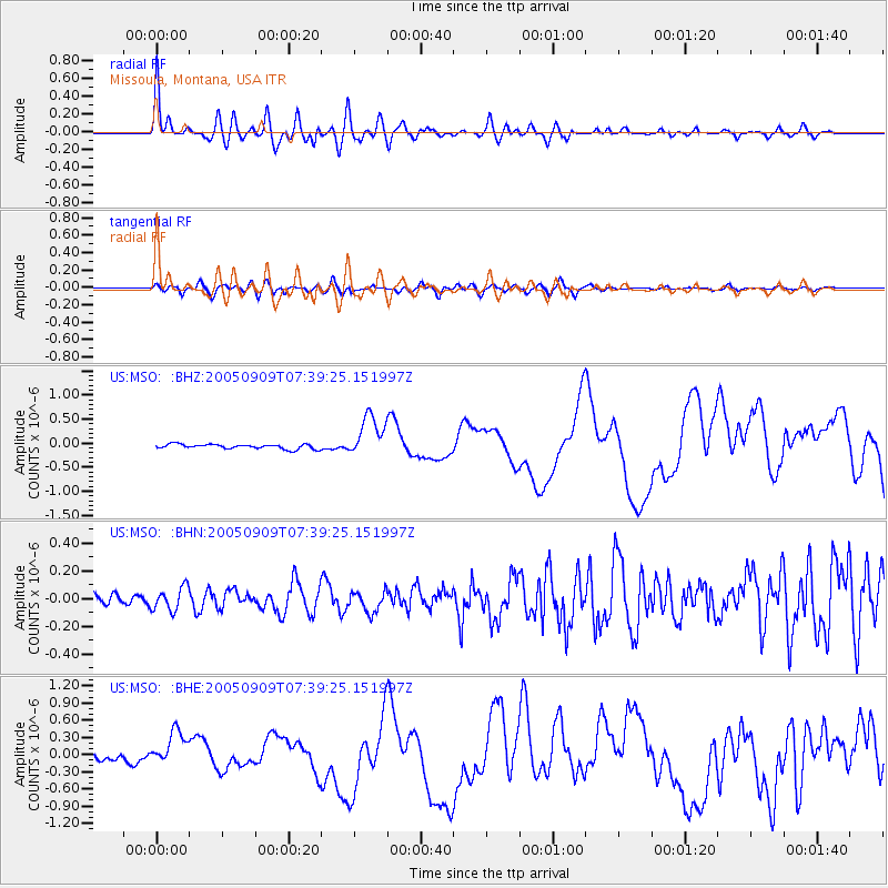
Signal To Noise
| Channel | StoN | STA | LTA |
| US:MSO: :BHN:20050909T07:39:25.151997Z | 1.3192514 | 8.496351E-8 | 6.4402826E-8 |
| US:MSO: :BHE:20050909T07:39:25.151997Z | 4.3861513 | 3.1361003E-7 | 7.150005E-8 |
| US:MSO: :BHZ:20050909T07:39:25.151997Z | 9.036041 | 4.318264E-7 | 4.778934E-8 |
| Arrivals |
| Ps | 9.3 SECOND |
| PpPs | 29 SECOND |
| PsPs/PpSs | 38 SECOND |


