You are here: Home > Network List > US - United States National Seismic Network Stations List
> Station MSO Missoula, Montana, USA > Earthquake Result Viewer
MSO Missoula, Montana, USA - Earthquake Result Viewer

| Earthquake location: |
Eastern Honshu, Japan |
| Earthquake latitude/longitude: |
39.8/141.5 |
| Earthquake time(UTC): |
2008/07/23 (205) 15:26:19 GMT |
| Earthquake Depth: |
108 km |
| Earthquake Magnitude: |
6.6 MB, 6.8 MW, 6.8 MW |
| Earthquake Catalog/Contributor: |
WHDF/NEIC |
|
| Network: |
US United States National Seismic Network |
| Station: |
MSO Missoula, Montana, USA |
| Lat/Lon: |
46.83 N/113.94 W |
| Elevation: |
1264 m |
|
| Distance: |
70.7 deg |
| Az: |
44.745 deg |
| Baz: |
307.831 deg |
| Ray Param: |
0.054526683 |
| Estimated Moho Depth: |
69.0 km |
| Estimated Crust Vp/Vs: |
2.01 |
| Assumed Crust Vp: |
6.353 km/s |
| Estimated Crust Vs: |
3.161 km/s |
| Estimated Crust Poisson's Ratio: |
0.34 |
|
| Radial Match: |
95.78174 % |
| Radial Bump: |
400 |
| Transverse Match: |
90.982025 % |
| Transverse Bump: |
400 |
| SOD ConfigId: |
2504 |
| Insert Time: |
2010-03-05 02:11:20.789 +0000 |
| GWidth: |
2.5 |
| Max Bumps: |
400 |
| Tol: |
0.001 |
|
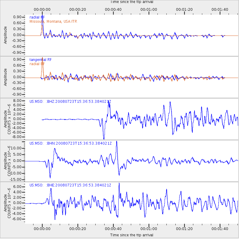
Signal To Noise
| Channel | StoN | STA | LTA |
| US:MSO: :BHN:20080723T15:36:53.384021Z | 82.85269 | 4.5630695E-6 | 5.5074487E-8 |
| US:MSO: :BHE:20080723T15:36:53.384021Z | 21.523481 | 1.5760429E-6 | 7.322435E-8 |
| US:MSO: :BHZ:20080723T15:36:53.384021Z | 33.49723 | 2.9001656E-6 | 8.657926E-8 |
| Arrivals |
| Ps | 11 SECOND |
| PpPs | 32 SECOND |
| PsPs/PpSs | 43 SECOND |


