You are here: Home > Network List > NN - Western Great Basin/Eastern Sierra Nevada Stations List
> Station VCN Virginia City, Nevada gps > Earthquake Result Viewer
VCN Virginia City, Nevada gps - Earthquake Result Viewer
| Earthquake location: |
Near Coast Of Chiapas, Mexico |
| Earthquake latitude/longitude: |
14.4/-93.1 |
| Earthquake time(UTC): |
2016/04/25 (116) 07:07:09 GMT |
| Earthquake Depth: |
26 km |
| Earthquake Magnitude: |
5.6 MB |
| Earthquake Catalog/Contributor: |
NEIC PDE/NEIC COMCAT |
|
| Network: |
NN Western Great Basin/Eastern Sierra Nevada |
| Station: |
VCN Virginia City, Nevada gps |
| Lat/Lon: |
39.30 N/119.65 W |
| Elevation: |
1928 m |
|
| Distance: |
34.0 deg |
| Az: |
321.726 deg |
| Baz: |
129.334 deg |
| Ray Param: |
0.07789378 |
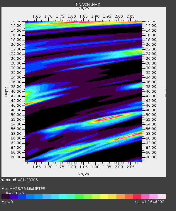
| Estimated Moho Depth: |
58.75 km |
| Estimated Crust Vp/Vs: |
2.04 |
| Assumed Crust Vp: |
6.279 km/s |
| Estimated Crust Vs: |
3.082 km/s |
| Estimated Crust Poisson's Ratio: |
0.34 |
|
| Radial Match: |
81.28306 % |
| Radial Bump: |
400 |
| Transverse Match: |
71.67444 % |
| Transverse Bump: |
400 |
| SOD ConfigId: |
7422571 |
| Insert Time: |
2019-04-22 11:16:36.128 +0000 |
| GWidth: |
2.5 |
| Max Bumps: |
400 |
| Tol: |
0.001 |
|

Signal To Noise
| Channel | StoN | STA | LTA |
| NN:VCN: :HHZ:20160425T07:13:20.455002Z | 2.2125793 | 5.9262936E-7 | 2.6784548E-7 |
| NN:VCN: :HHN:20160425T07:13:20.455002Z | 1.505673 | 2.8362015E-7 | 1.8836768E-7 |
| NN:VCN: :HHE:20160425T07:13:20.455002Z | 1.5217592 | 4.3118035E-7 | 2.8334335E-7 |
| Arrivals |
| Ps | 10 SECOND |
| PpPs | 27 SECOND |
| PsPs/PpSs | 37 SECOND |


