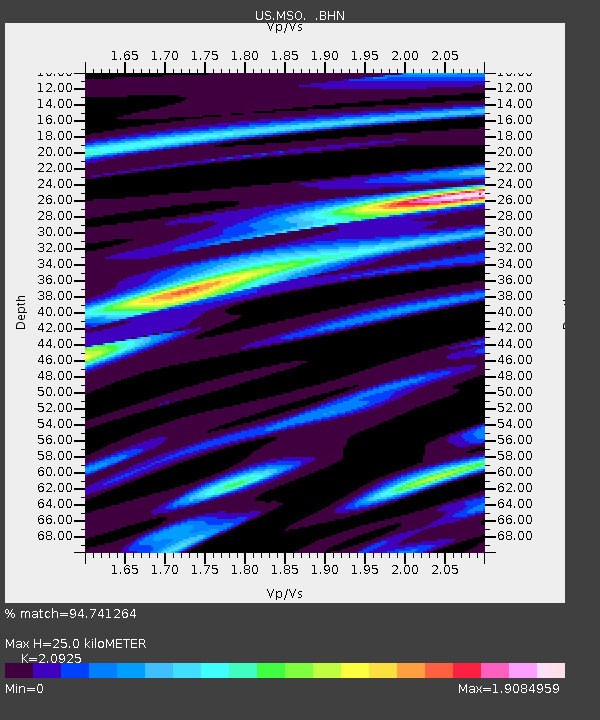
MSO Missoula, Montana, USA - Earthquake Result Viewer
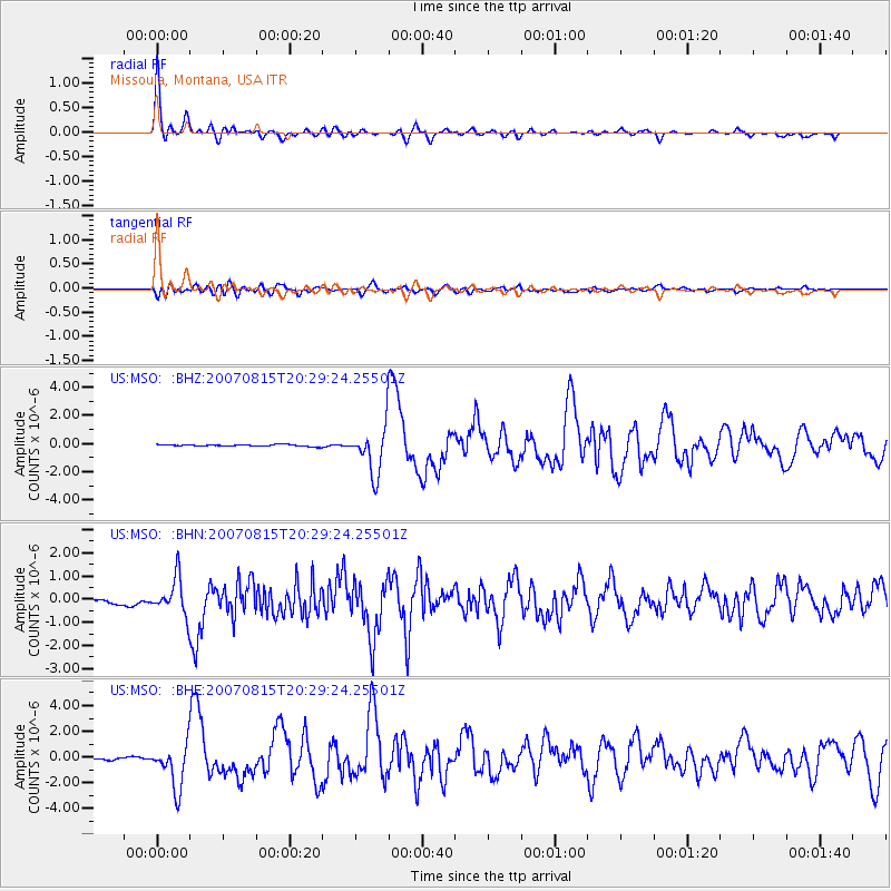
Earthquake location: Andreanof Islands, Aleutian Is.
Earthquake latitude/longitude: 50.3/-177.5
Earthquake time(UTC): 2007/08/15 (227) 20:22:11 GMT
Earthquake Depth: 9.0 km
Earthquake Magnitude: 6.3 MB, 6.2 MS, 6.4 MW, 5.9 ML
Earthquake Catalog/Contributor: WHDF/NEIC
Network: US United States National Seismic Network
Station: MSO Missoula, Montana, USA
Lat/Lon: 46.83 N/113.94 W
Elevation: 1264 m
Distance: 41.1 deg
Az: 69.352 deg
Baz: 299.119 deg
Ray Param: 0.074011296
Estimated Moho Depth: 25.0 km
Estimated Crust Vp/Vs: 2.09
Assumed Crust Vp: 6.353 km/s
Estimated Crust Vs: 3.036 km/s
Estimated Crust Poisson's Ratio: 0.35
Radial Match: 94.741264 %
Radial Bump: 400
Transverse Match: 84.22946 %
Transverse Bump: 400
SOD ConfigId: 2564
Insert Time: 2010-03-05 02:12:58.182 +0000
GWidth: 2.5
Max Bumps: 400
Tol: 0.001

Signal To Noise

ChannelStoNSTALTA
US:MSO: :BHN:20070815T20:29:24.25501Z4.808167.849628E-71.6325639E-7
US:MSO: :BHE:20070815T20:29:24.25501Z9.5882041.7669902E-61.8428791E-7
US:MSO: :BHZ:20070815T20:29:24.25501Z27.0207671.6881688E-66.2476715E-8
Arrivals
Ps4.6 SECOND
PpPs11 SECOND
PsPs/PpSs16 SECOND