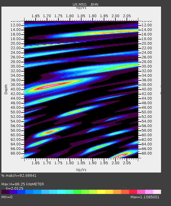
MSO Missoula, Montana, USA - Earthquake Result Viewer

Earthquake location: Near West Coast Of Honshu, Japan
Earthquake latitude/longitude: 37.5/138.4
Earthquake time(UTC): 2007/07/16 (197) 01:13:22 GMT
Earthquake Depth: 12 km
Earthquake Magnitude: 6.5 MB, 6.4 MS, 6.6 MW, 6.5 MW
Earthquake Catalog/Contributor: WHDF/NEIC
Network: US United States National Seismic Network
Station: MSO Missoula, Montana, USA
Lat/Lon: 46.83 N/113.94 W
Elevation: 1264 m
Distance: 74.0 deg
Az: 42.91 deg
Baz: 307.975 deg
Ray Param: 0.05263456
Estimated Moho Depth: 69.25 km
Estimated Crust Vp/Vs: 2.01
Assumed Crust Vp: 6.353 km/s
Estimated Crust Vs: 3.157 km/s
Estimated Crust Poisson's Ratio: 0.34
Radial Match: 92.89941 %
Radial Bump: 400
Transverse Match: 84.51359 %
Transverse Bump: 400
SOD ConfigId: 2564
Insert Time: 2010-03-05 02:13:16.440 +0000
GWidth: 2.5
Max Bumps: 400
Tol: 0.001

Signal To Noise

ChannelStoNSTALTA
US:MSO: :BHN:20070716T01:24:26.304021Z10.1994715.0272047E-74.928887E-8
US:MSO: :BHE:20070716T01:24:26.304021Z11.6691018.219077E-77.043454E-8
US:MSO: :BHZ:20070716T01:24:26.304021Z36.838591.2349461E-63.3523165E-8
Arrivals
Ps11 SECOND
PpPs32 SECOND
PsPs/PpSs43 SECOND