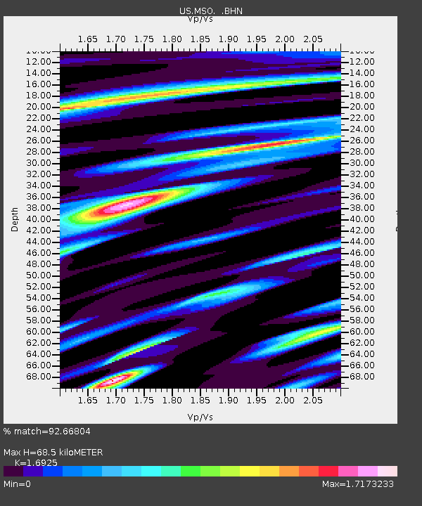
MSO Missoula, Montana, USA - Earthquake Result Viewer

Earthquake location: Fox Islands, Aleutian Islands
Earthquake latitude/longitude: 52.5/-168.0
Earthquake time(UTC): 2007/07/15 (196) 13:08:00 GMT
Earthquake Depth: 10 km
Earthquake Magnitude: 5.8 MB, 5.9 MS, 6.1 MW, 6.0 MW
Earthquake Catalog/Contributor: WHDF/NEIC
Network: US United States National Seismic Network
Station: MSO Missoula, Montana, USA
Lat/Lon: 46.83 N/113.94 W
Elevation: 1264 m
Distance: 34.8 deg
Az: 77.218 deg
Baz: 299.691 deg
Ray Param: 0.07756703
Estimated Moho Depth: 68.5 km
Estimated Crust Vp/Vs: 1.69
Assumed Crust Vp: 6.353 km/s
Estimated Crust Vs: 3.754 km/s
Estimated Crust Poisson's Ratio: 0.23
Radial Match: 92.66804 %
Radial Bump: 400
Transverse Match: 76.2754 %
Transverse Bump: 400
SOD ConfigId: 2564
Insert Time: 2010-03-05 02:13:18.107 +0000
GWidth: 2.5
Max Bumps: 400
Tol: 0.001

Signal To Noise

ChannelStoNSTALTA
US:MSO: :BHN:20070715T13:14:20.579012Z2.27536561.2758125E-75.6070657E-8
US:MSO: :BHE:20070715T13:14:20.579012Z4.78218032.3019945E-74.8136922E-8
US:MSO: :BHZ:20070715T13:14:20.579012Z7.75095272.3382515E-73.016728E-8
Arrivals
Ps8.1 SECOND
PpPs27 SECOND
PsPs/PpSs35 SECOND