You are here: Home > Network List > US - United States National Seismic Network Stations List
> Station MSO Missoula, Montana, USA > Earthquake Result Viewer
MSO Missoula, Montana, USA - Earthquake Result Viewer
| Earthquake location: |
Vanuatu Islands |
| Earthquake latitude/longitude: |
-13.0/166.5 |
| Earthquake time(UTC): |
2009/10/07 (280) 22:03:14 GMT |
| Earthquake Depth: |
45 km |
| Earthquake Magnitude: |
6.4 MB, 7.3 MS, 7.6 MW, 7.7 MW |
| Earthquake Catalog/Contributor: |
WHDF/NEIC |
|
| Network: |
US United States National Seismic Network |
| Station: |
MSO Missoula, Montana, USA |
| Lat/Lon: |
46.83 N/113.94 W |
| Elevation: |
1264 m |
|
| Distance: |
92.4 deg |
| Az: |
42.516 deg |
| Baz: |
253.602 deg |
| Ray Param: |
0.04145546 |
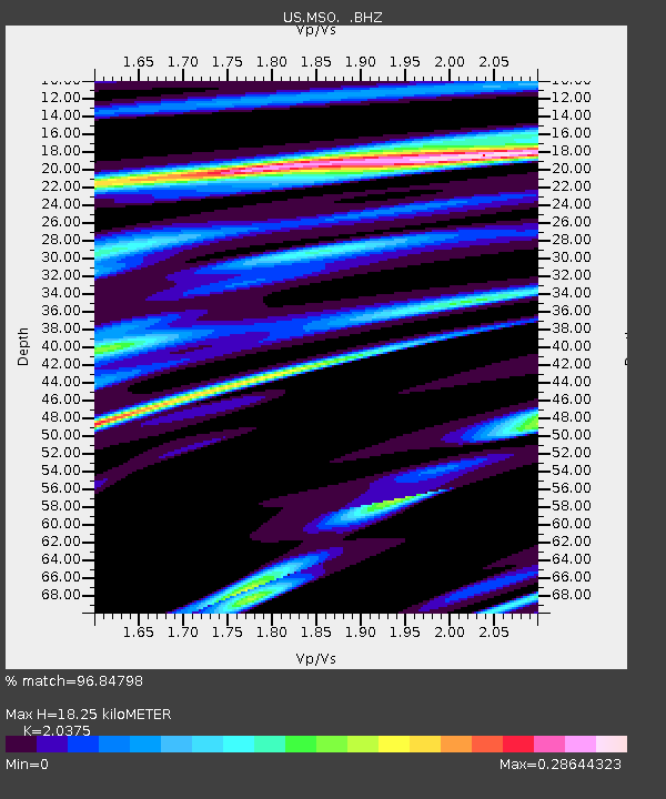
| Estimated Moho Depth: |
18.25 km |
| Estimated Crust Vp/Vs: |
2.04 |
| Assumed Crust Vp: |
6.353 km/s |
| Estimated Crust Vs: |
3.118 km/s |
| Estimated Crust Poisson's Ratio: |
0.34 |
|
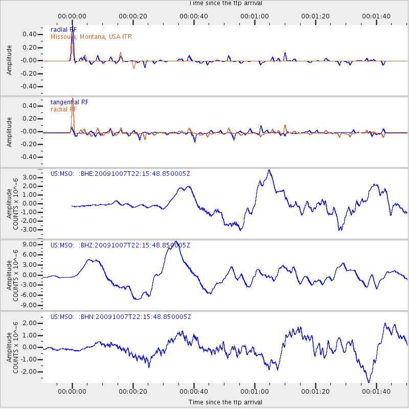
| Radial Match: |
96.84798 % |
| Radial Bump: |
251 |
| Transverse Match: |
83.627426 % |
| Transverse Bump: |
400 |
| SOD ConfigId: |
2622 |
| Insert Time: |
2010-03-05 02:14:05.735 +0000 |
| GWidth: |
2.5 |
| Max Bumps: |
400 |
| Tol: |
0.001 |
|
Signal To Noise
| Channel | StoN | STA | LTA |
| US:MSO: :BHZ:20091007T22:15:48.850005Z | 9.691554 | 1.98228E-6 | 2.0453686E-7 |
| US:MSO: :BHN:20091007T22:15:48.850005Z | 0.556537 | 1.1395386E-7 | 2.0475522E-7 |
| US:MSO: :BHE:20091007T22:15:48.850005Z | 4.814854 | 7.526466E-7 | 1.5631763E-7 |
| Arrivals |
| Ps | 3.0 SECOND |
| PpPs | 8.6 SECOND |
| PsPs/PpSs | 12 SECOND |


