You are here: Home > Network List > US - United States National Seismic Network Stations List
> Station MSO Missoula, Montana, USA > Earthquake Result Viewer
MSO Missoula, Montana, USA - Earthquake Result Viewer

| Earthquake location: |
North Of Svalbard |
| Earthquake latitude/longitude: |
80.3/-1.9 |
| Earthquake time(UTC): |
2009/03/06 (065) 10:50:29 GMT |
| Earthquake Depth: |
9.0 km |
| Earthquake Magnitude: |
6.6 MB, 6.5 MS, 6.5 MW, 6.4 MW |
| Earthquake Catalog/Contributor: |
WHDF/NEIC |
|
| Network: |
US United States National Seismic Network |
| Station: |
MSO Missoula, Montana, USA |
| Lat/Lon: |
46.83 N/113.94 W |
| Elevation: |
1264 m |
|
| Distance: |
47.7 deg |
| Az: |
300.68 deg |
| Baz: |
12.234 deg |
| Ray Param: |
0.069817945 |
| Estimated Moho Depth: |
37.0 km |
| Estimated Crust Vp/Vs: |
1.75 |
| Assumed Crust Vp: |
6.353 km/s |
| Estimated Crust Vs: |
3.62 km/s |
| Estimated Crust Poisson's Ratio: |
0.26 |
|
| Radial Match: |
95.67107 % |
| Radial Bump: |
400 |
| Transverse Match: |
89.56217 % |
| Transverse Bump: |
400 |
| SOD ConfigId: |
2658 |
| Insert Time: |
2010-03-05 02:14:20.101 +0000 |
| GWidth: |
2.5 |
| Max Bumps: |
400 |
| Tol: |
0.001 |
|
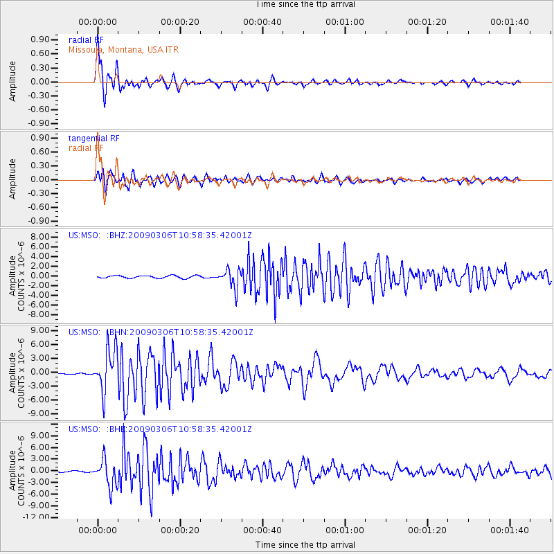
Signal To Noise
| Channel | StoN | STA | LTA |
| US:MSO: :BHN:20090306T10:58:35.42001Z | 50.253174 | 4.842885E-6 | 9.636973E-8 |
| US:MSO: :BHE:20090306T10:58:35.42001Z | 26.745464 | 3.666278E-6 | 1.3708036E-7 |
| US:MSO: :BHZ:20090306T10:58:35.42001Z | 7.2531776 | 1.9286072E-6 | 2.6589822E-7 |
| Arrivals |
| Ps | 4.7 SECOND |
| PpPs | 15 SECOND |
| PsPs/PpSs | 20 SECOND |


