You are here: Home > Network List > AK - Alaska Regional Network Stations List
> Station MDM Murphy Dome > Earthquake Result Viewer
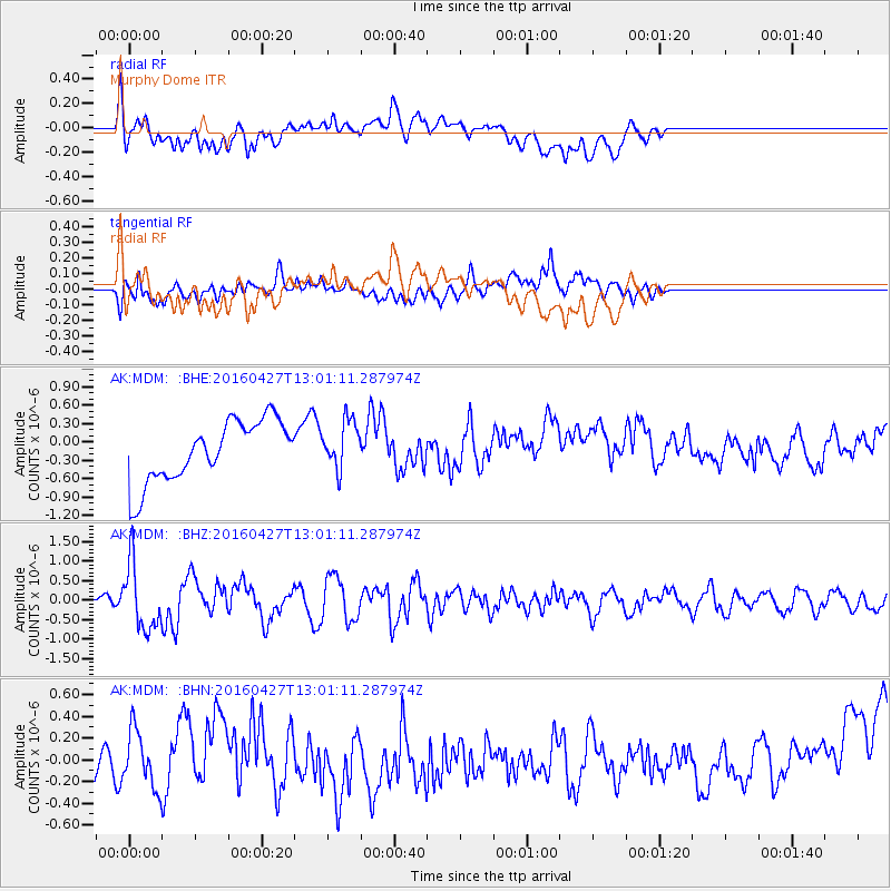
MDM Murphy Dome - Earthquake Result Viewer
*The percent match for this event was below the threshold and hence no stack was calculated.
| Earthquake location: |
Near Coast Of Chiapas, Mexico |
| Earthquake latitude/longitude: |
14.6/-93.0 |
| Earthquake time(UTC): |
2016/04/27 (118) 12:51:22 GMT |
| Earthquake Depth: |
35 km |
| Earthquake Magnitude: |
5.8 MB |
| Earthquake Catalog/Contributor: |
NEIC PDE/NEIC COMCAT |
|
| Network: |
AK Alaska Regional Network |
| Station: |
MDM Murphy Dome |
| Lat/Lon: |
64.96 N/148.23 W |
| Elevation: |
634 m |
|
| Distance: |
62.5 deg |
| Az: |
336.787 deg |
| Baz: |
116.277 deg |
| Ray Param: |
$rayparam |
*The percent match for this event was below the threshold and hence was not used in the summary stack. |
|
| Radial Match: |
35.301426 % |
| Radial Bump: |
400 |
| Transverse Match: |
25.593302 % |
| Transverse Bump: |
400 |
| SOD ConfigId: |
7422571 |
| Insert Time: |
2019-04-22 11:25:24.969 +0000 |
| GWidth: |
2.5 |
| Max Bumps: |
400 |
| Tol: |
0.001 |
|
Signal To Noise
| Channel | StoN | STA | LTA |
| AK:MDM: :BHZ:20160427T13:01:11.287974Z | 4.384424 | 8.413786E-7 | 1.9190173E-7 |
| AK:MDM: :BHN:20160427T13:01:11.287974Z | 1.8743372 | 2.597078E-7 | 1.3855981E-7 |
| AK:MDM: :BHE:20160427T13:01:11.287974Z | 0.86546546 | 3.8199065E-7 | 4.413702E-7 |
| Arrivals |
| Ps | |
| PpPs | |
| PsPs/PpSs | |


