You are here: Home > Network List > AU - Australian Seismological Centre Stations List
> Station PSAB2 Pilbara Seismic Array Element B2 > Earthquake Result Viewer
PSAB2 Pilbara Seismic Array Element B2 - Earthquake Result Viewer
| Earthquake location: |
Solomon Islands |
| Earthquake latitude/longitude: |
-9.3/157.9 |
| Earthquake time(UTC): |
2015/08/12 (224) 18:49:23 GMT |
| Earthquake Depth: |
5.0 km |
| Earthquake Magnitude: |
6.4 MWB, 6.8 MI, 6.9 MI |
| Earthquake Catalog/Contributor: |
NEIC PDE/NEIC COMCAT |
|
| Network: |
AU Australian Seismological Centre |
| Station: |
PSAB2 Pilbara Seismic Array Element B2 |
| Lat/Lon: |
21.55 S/119.86 E |
| Elevation: |
302 m |
|
| Distance: |
38.6 deg |
| Az: |
247.09 deg |
| Baz: |
77.581 deg |
| Ray Param: |
0.07550931 |
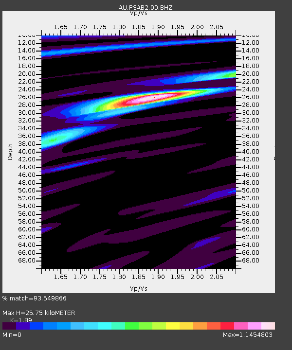
| Estimated Moho Depth: |
25.75 km |
| Estimated Crust Vp/Vs: |
1.89 |
| Assumed Crust Vp: |
6.464 km/s |
| Estimated Crust Vs: |
3.42 km/s |
| Estimated Crust Poisson's Ratio: |
0.31 |
|
| Radial Match: |
93.549866 % |
| Radial Bump: |
170 |
| Transverse Match: |
54.349644 % |
| Transverse Bump: |
400 |
| SOD ConfigId: |
1085051 |
| Insert Time: |
2015-08-26 18:57:13.445 +0000 |
| GWidth: |
2.5 |
| Max Bumps: |
400 |
| Tol: |
0.001 |
|

Signal To Noise
| Channel | StoN | STA | LTA |
| AU:PSAB2:00:BHZ:20150812T18:56:16.144012Z | 4.9022803 | 2.1746596E-6 | 4.4360164E-7 |
| AU:PSAB2:00:BH1:20150812T18:56:16.144012Z | 2.2161427 | 9.804756E-7 | 4.424244E-7 |
| AU:PSAB2:00:BH2:20150812T18:56:16.144012Z | 1.7426275 | 7.5803706E-7 | 4.3499662E-7 |
| Arrivals |
| Ps | 3.8 SECOND |
| PpPs | 11 SECOND |
| PsPs/PpSs | 15 SECOND |


