You are here: Home > Network List > CI - Caltech Regional Seismic Network Stations List
> Station MPM Manuel Prospect Mine, California, USA > Earthquake Result Viewer
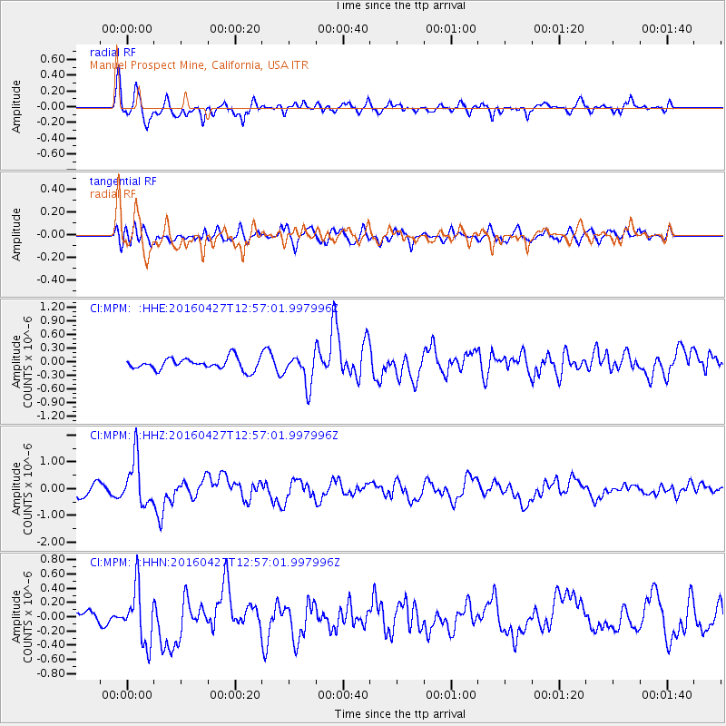
MPM Manuel Prospect Mine, California, USA - Earthquake Result Viewer
*The percent match for this event was below the threshold and hence no stack was calculated.
| Earthquake location: |
Near Coast Of Chiapas, Mexico |
| Earthquake latitude/longitude: |
14.6/-93.0 |
| Earthquake time(UTC): |
2016/04/27 (118) 12:51:22 GMT |
| Earthquake Depth: |
35 km |
| Earthquake Magnitude: |
5.8 MB |
| Earthquake Catalog/Contributor: |
NEIC PDE/NEIC COMCAT |
|
| Network: |
CI Caltech Regional Seismic Network |
| Station: |
MPM Manuel Prospect Mine, California, USA |
| Lat/Lon: |
36.06 N/117.49 W |
| Elevation: |
185 m |
|
| Distance: |
30.6 deg |
| Az: |
318.721 deg |
| Baz: |
127.971 deg |
| Ray Param: |
$rayparam |
*The percent match for this event was below the threshold and hence was not used in the summary stack. |
|
| Radial Match: |
73.808525 % |
| Radial Bump: |
400 |
| Transverse Match: |
46.65726 % |
| Transverse Bump: |
400 |
| SOD ConfigId: |
7422571 |
| Insert Time: |
2019-04-22 11:26:58.913 +0000 |
| GWidth: |
2.5 |
| Max Bumps: |
400 |
| Tol: |
0.001 |
|
Signal To Noise
| Channel | StoN | STA | LTA |
| CI:MPM: :HHZ:20160427T12:57:01.997996Z | 4.233272 | 8.690496E-7 | 2.0529028E-7 |
| CI:MPM: :HHN:20160427T12:57:01.997996Z | 3.4610639 | 3.8797796E-7 | 1.12097894E-7 |
| CI:MPM: :HHE:20160427T12:57:01.997996Z | 2.480994 | 3.8003895E-7 | 1.5318012E-7 |
| Arrivals |
| Ps | |
| PpPs | |
| PsPs/PpSs | |


