You are here: Home > Network List > CI - Caltech Regional Seismic Network Stations List
> Station SMM Simmler, CA, USA > Earthquake Result Viewer
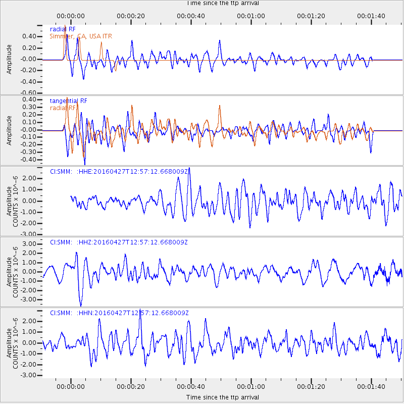
SMM Simmler, CA, USA - Earthquake Result Viewer
*The percent match for this event was below the threshold and hence no stack was calculated.
| Earthquake location: |
Near Coast Of Chiapas, Mexico |
| Earthquake latitude/longitude: |
14.6/-93.0 |
| Earthquake time(UTC): |
2016/04/27 (118) 12:51:22 GMT |
| Earthquake Depth: |
35 km |
| Earthquake Magnitude: |
5.8 MB |
| Earthquake Catalog/Contributor: |
NEIC PDE/NEIC COMCAT |
|
| Network: |
CI Caltech Regional Seismic Network |
| Station: |
SMM Simmler, CA, USA |
| Lat/Lon: |
35.31 N/120.00 W |
| Elevation: |
599 m |
|
| Distance: |
31.9 deg |
| Az: |
315.262 deg |
| Baz: |
123.557 deg |
| Ray Param: |
$rayparam |
*The percent match for this event was below the threshold and hence was not used in the summary stack. |
|
| Radial Match: |
59.609573 % |
| Radial Bump: |
400 |
| Transverse Match: |
68.87275 % |
| Transverse Bump: |
400 |
| SOD ConfigId: |
7422571 |
| Insert Time: |
2019-04-22 11:27:02.695 +0000 |
| GWidth: |
2.5 |
| Max Bumps: |
400 |
| Tol: |
0.001 |
|
Signal To Noise
| Channel | StoN | STA | LTA |
| CI:SMM: :HHZ:20160427T12:57:12.668009Z | 3.8619971 | 1.7020428E-6 | 4.4071572E-7 |
| CI:SMM: :HHN:20160427T12:57:12.668009Z | 0.5168963 | 2.9790252E-7 | 5.7632934E-7 |
| CI:SMM: :HHE:20160427T12:57:12.668009Z | 3.0869298 | 1.1042017E-6 | 3.5770222E-7 |
| Arrivals |
| Ps | |
| PpPs | |
| PsPs/PpSs | |


