You are here: Home > Network List > CN - Canadian National Seismograph Network Stations List
> Station INK INUVIK, NT > Earthquake Result Viewer
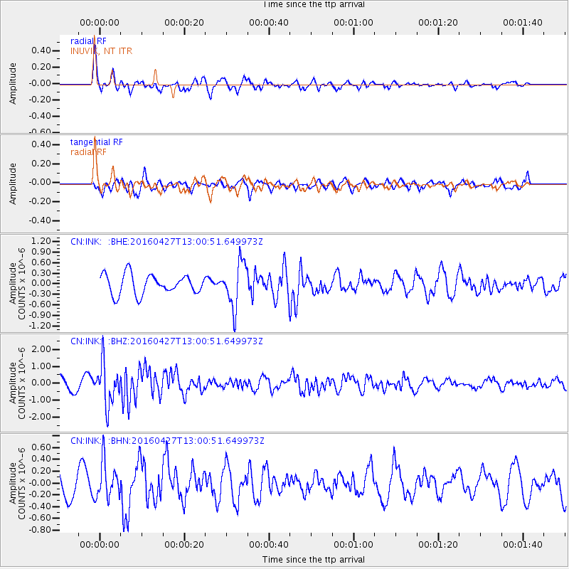
INK INUVIK, NT - Earthquake Result Viewer
*The percent match for this event was below the threshold and hence no stack was calculated.
| Earthquake location: |
Near Coast Of Chiapas, Mexico |
| Earthquake latitude/longitude: |
14.6/-93.0 |
| Earthquake time(UTC): |
2016/04/27 (118) 12:51:22 GMT |
| Earthquake Depth: |
35 km |
| Earthquake Magnitude: |
5.8 MB |
| Earthquake Catalog/Contributor: |
NEIC PDE/NEIC COMCAT |
|
| Network: |
CN Canadian National Seismograph Network |
| Station: |
INK INUVIK, NT |
| Lat/Lon: |
68.31 N/133.53 W |
| Elevation: |
44 m |
|
| Distance: |
59.6 deg |
| Az: |
343.728 deg |
| Baz: |
133.138 deg |
| Ray Param: |
$rayparam |
*The percent match for this event was below the threshold and hence was not used in the summary stack. |
|
| Radial Match: |
72.07325 % |
| Radial Bump: |
400 |
| Transverse Match: |
49.74775 % |
| Transverse Bump: |
400 |
| SOD ConfigId: |
7422571 |
| Insert Time: |
2019-04-22 11:27:19.110 +0000 |
| GWidth: |
2.5 |
| Max Bumps: |
400 |
| Tol: |
0.001 |
|
Signal To Noise
| Channel | StoN | STA | LTA |
| CN:INK: :BHZ:20160427T13:00:51.649973Z | 4.1118174 | 1.2353277E-6 | 3.004335E-7 |
| CN:INK: :BHN:20160427T13:00:51.649973Z | 1.245853 | 3.083879E-7 | 2.4753155E-7 |
| CN:INK: :BHE:20160427T13:00:51.649973Z | 2.399899 | 6.640842E-7 | 2.767134E-7 |
| Arrivals |
| Ps | |
| PpPs | |
| PsPs/PpSs | |


