You are here: Home > Network List > US - United States National Seismic Network Stations List
> Station MSO Missoula, Montana, USA > Earthquake Result Viewer
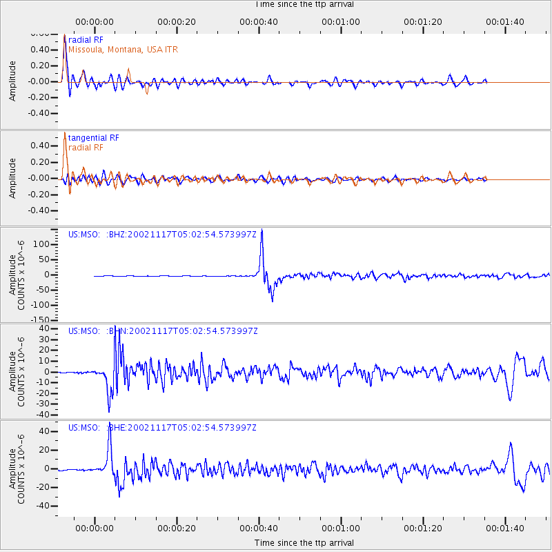
MSO Missoula, Montana, USA - Earthquake Result Viewer
*The percent match for this event was below the threshold and hence no stack was calculated.
| Earthquake location: |
Northwest Of Kuril Islands |
| Earthquake latitude/longitude: |
47.8/146.2 |
| Earthquake time(UTC): |
2002/11/17 (321) 04:53:53 GMT |
| Earthquake Depth: |
459 km |
| Earthquake Magnitude: |
7.3 MW, 7.3 MW |
| Earthquake Catalog/Contributor: |
WHDF/NEIC |
|
| Network: |
US United States National Seismic Network |
| Station: |
MSO Missoula, Montana, USA |
| Lat/Lon: |
46.83 N/113.94 W |
| Elevation: |
1264 m |
|
| Distance: |
62.7 deg |
| Az: |
49.552 deg |
| Baz: |
311.679 deg |
| Ray Param: |
$rayparam |
*The percent match for this event was below the threshold and hence was not used in the summary stack. |
|
| Radial Match: |
89.6644 % |
| Radial Bump: |
400 |
| Transverse Match: |
73.45968 % |
| Transverse Bump: |
400 |
| SOD ConfigId: |
110177 |
| Insert Time: |
2010-03-05 02:16:45.111 +0000 |
| GWidth: |
2.5 |
| Max Bumps: |
400 |
| Tol: |
0.001 |
|
Signal To Noise
| Channel | StoN | STA | LTA |
| US:MSO: :BHN:20021117T05:02:54.573997Z | 39.28387 | 1.3171752E-5 | 3.3529668E-7 |
| US:MSO: :BHE:20021117T05:02:54.573997Z | 47.87315 | 1.5940159E-5 | 3.3296658E-7 |
| US:MSO: :BHZ:20021117T05:02:54.573997Z | 135.46194 | 4.50146E-5 | 3.3230438E-7 |
| Arrivals |
| Ps | |
| PpPs | |
| PsPs/PpSs | |


