You are here: Home > Network List > US - United States National Seismic Network Stations List
> Station MSO Missoula, Montana, USA > Earthquake Result Viewer
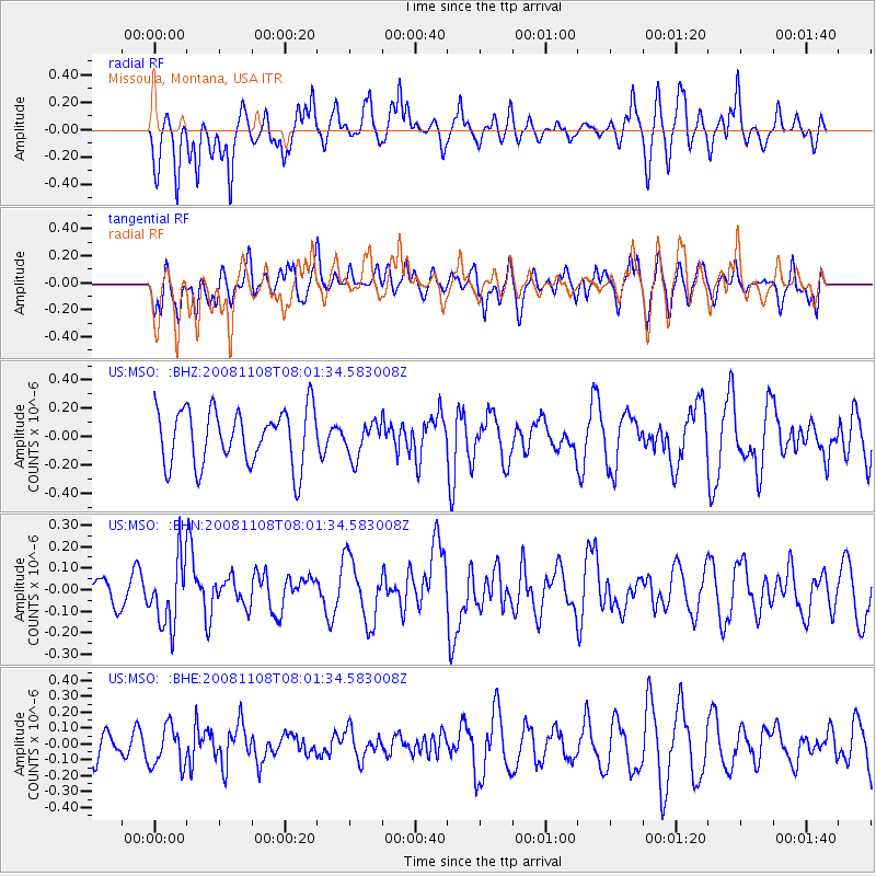
MSO Missoula, Montana, USA - Earthquake Result Viewer
*The percent match for this event was below the threshold and hence no stack was calculated.
| Earthquake location: |
Tonga Islands |
| Earthquake latitude/longitude: |
-15.2/-174.2 |
| Earthquake time(UTC): |
2008/11/08 (313) 07:49:59 GMT |
| Earthquake Depth: |
121 km |
| Earthquake Magnitude: |
6.0 MW, 5.4 MB, 6.0 MW |
| Earthquake Catalog/Contributor: |
WHDF/NEIC |
|
| Network: |
US United States National Seismic Network |
| Station: |
MSO Missoula, Montana, USA |
| Lat/Lon: |
46.83 N/113.94 W |
| Elevation: |
1264 m |
|
| Distance: |
82.0 deg |
| Az: |
37.027 deg |
| Baz: |
237.85 deg |
| Ray Param: |
$rayparam |
*The percent match for this event was below the threshold and hence was not used in the summary stack. |
|
| Radial Match: |
56.173676 % |
| Radial Bump: |
400 |
| Transverse Match: |
67.14368 % |
| Transverse Bump: |
400 |
| SOD ConfigId: |
2658 |
| Insert Time: |
2010-03-05 02:16:51.761 +0000 |
| GWidth: |
2.5 |
| Max Bumps: |
400 |
| Tol: |
0.001 |
|
Signal To Noise
| Channel | StoN | STA | LTA |
| US:MSO: :BHN:20081108T08:01:34.583008Z | 1.8410867 | 1.5266332E-7 | 8.292022E-8 |
| US:MSO: :BHE:20081108T08:01:34.583008Z | 1.5185661 | 1.301015E-7 | 8.56739E-8 |
| US:MSO: :BHZ:20081108T08:01:34.583008Z | 0.6215016 | 1.2272332E-7 | 1.9746258E-7 |
| Arrivals |
| Ps | |
| PpPs | |
| PsPs/PpSs | |


