You are here: Home > Network List > US - United States National Seismic Network Stations List
> Station MSO Missoula, Montana, USA > Earthquake Result Viewer
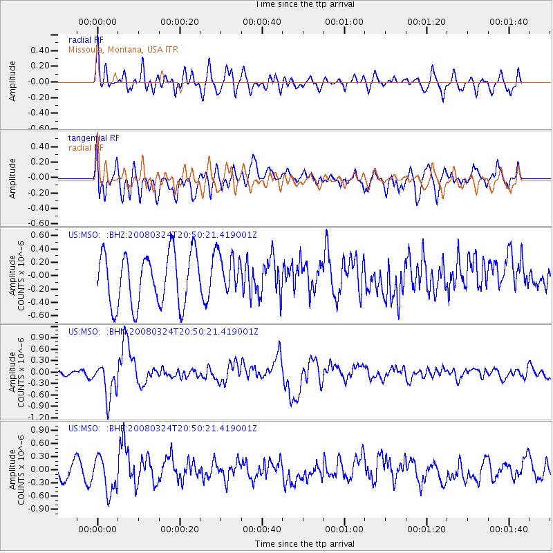
MSO Missoula, Montana, USA - Earthquake Result Viewer
*The percent match for this event was below the threshold and hence no stack was calculated.
| Earthquake location: |
Chile-Bolivia Border Region |
| Earthquake latitude/longitude: |
-20.0/-69.0 |
| Earthquake time(UTC): |
2008/03/24 (084) 20:39:07 GMT |
| Earthquake Depth: |
120 km |
| Earthquake Magnitude: |
5.7 MB, 6.2 MW, 6.1 MW |
| Earthquake Catalog/Contributor: |
WHDF/NEIC |
|
| Network: |
US United States National Seismic Network |
| Station: |
MSO Missoula, Montana, USA |
| Lat/Lon: |
46.83 N/113.94 W |
| Elevation: |
1264 m |
|
| Distance: |
77.9 deg |
| Az: |
330.246 deg |
| Baz: |
137.192 deg |
| Ray Param: |
$rayparam |
*The percent match for this event was below the threshold and hence was not used in the summary stack. |
|
| Radial Match: |
58.822784 % |
| Radial Bump: |
400 |
| Transverse Match: |
49.64441 % |
| Transverse Bump: |
400 |
| SOD ConfigId: |
2504 |
| Insert Time: |
2010-03-05 02:16:55.673 +0000 |
| GWidth: |
2.5 |
| Max Bumps: |
400 |
| Tol: |
0.001 |
|
Signal To Noise
| Channel | StoN | STA | LTA |
| US:MSO: :BHN:20080324T20:50:21.419001Z | 5.027003 | 4.8402063E-7 | 9.628414E-8 |
| US:MSO: :BHE:20080324T20:50:21.419001Z | 1.6383146 | 4.0713377E-7 | 2.485077E-7 |
| US:MSO: :BHZ:20080324T20:50:21.419001Z | 0.72349054 | 2.8362797E-7 | 3.920272E-7 |
| Arrivals |
| Ps | |
| PpPs | |
| PsPs/PpSs | |


