You are here: Home > Network List > TA - USArray Transportable Network (new EarthScope stations) Stations List
> Station J26L Joseph Creek, AK, USA > Earthquake Result Viewer
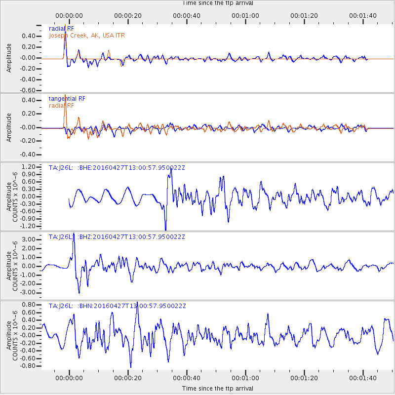
J26L Joseph Creek, AK, USA - Earthquake Result Viewer
*The percent match for this event was below the threshold and hence no stack was calculated.
| Earthquake location: |
Near Coast Of Chiapas, Mexico |
| Earthquake latitude/longitude: |
14.6/-93.0 |
| Earthquake time(UTC): |
2016/04/27 (118) 12:51:22 GMT |
| Earthquake Depth: |
35 km |
| Earthquake Magnitude: |
5.8 MB |
| Earthquake Catalog/Contributor: |
NEIC PDE/NEIC COMCAT |
|
| Network: |
TA USArray Transportable Network (new EarthScope stations) |
| Station: |
J26L Joseph Creek, AK, USA |
| Lat/Lon: |
64.50 N/143.56 W |
| Elevation: |
1144 m |
|
| Distance: |
60.6 deg |
| Az: |
337.416 deg |
| Baz: |
120.791 deg |
| Ray Param: |
$rayparam |
*The percent match for this event was below the threshold and hence was not used in the summary stack. |
|
| Radial Match: |
72.654144 % |
| Radial Bump: |
400 |
| Transverse Match: |
51.440296 % |
| Transverse Bump: |
400 |
| SOD ConfigId: |
7422571 |
| Insert Time: |
2019-04-22 11:30:40.898 +0000 |
| GWidth: |
2.5 |
| Max Bumps: |
400 |
| Tol: |
0.001 |
|
Signal To Noise
| Channel | StoN | STA | LTA |
| TA:J26L: :BHZ:20160427T13:00:57.950022Z | 6.0298367 | 1.6332447E-6 | 2.708605E-7 |
| TA:J26L: :BHN:20160427T13:00:57.950022Z | 1.0932293 | 3.494593E-7 | 3.1965783E-7 |
| TA:J26L: :BHE:20160427T13:00:57.950022Z | 3.3579667 | 6.737772E-7 | 2.0065036E-7 |
| Arrivals |
| Ps | |
| PpPs | |
| PsPs/PpSs | |


