You are here: Home > Network List > TA - USArray Transportable Network (new EarthScope stations) Stations List
> Station L20K Farewell, AK, USA > Earthquake Result Viewer
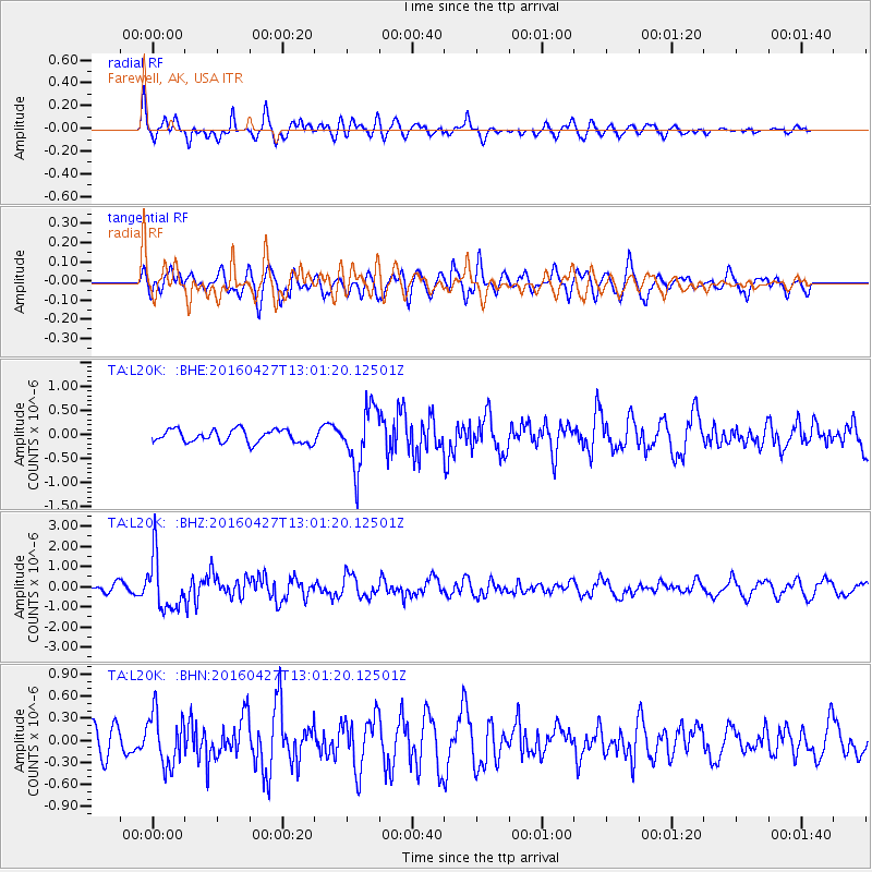
L20K Farewell, AK, USA - Earthquake Result Viewer
*The percent match for this event was below the threshold and hence no stack was calculated.
| Earthquake location: |
Near Coast Of Chiapas, Mexico |
| Earthquake latitude/longitude: |
14.6/-93.0 |
| Earthquake time(UTC): |
2016/04/27 (118) 12:51:22 GMT |
| Earthquake Depth: |
35 km |
| Earthquake Magnitude: |
5.8 MB |
| Earthquake Catalog/Contributor: |
NEIC PDE/NEIC COMCAT |
|
| Network: |
TA USArray Transportable Network (new EarthScope stations) |
| Station: |
L20K Farewell, AK, USA |
| Lat/Lon: |
62.48 N/153.88 W |
| Elevation: |
673 m |
|
| Distance: |
63.9 deg |
| Az: |
333.124 deg |
| Baz: |
109.564 deg |
| Ray Param: |
$rayparam |
*The percent match for this event was below the threshold and hence was not used in the summary stack. |
|
| Radial Match: |
69.99057 % |
| Radial Bump: |
400 |
| Transverse Match: |
59.730232 % |
| Transverse Bump: |
400 |
| SOD ConfigId: |
7422571 |
| Insert Time: |
2019-04-22 11:30:50.284 +0000 |
| GWidth: |
2.5 |
| Max Bumps: |
400 |
| Tol: |
0.001 |
|
Signal To Noise
| Channel | StoN | STA | LTA |
| TA:L20K: :BHZ:20160427T13:01:20.12501Z | 4.9838133 | 1.302385E-6 | 2.6132298E-7 |
| TA:L20K: :BHN:20160427T13:01:20.12501Z | 1.5742818 | 3.523315E-7 | 2.2380459E-7 |
| TA:L20K: :BHE:20160427T13:01:20.12501Z | 4.6269627 | 6.3552574E-7 | 1.3735269E-7 |
| Arrivals |
| Ps | |
| PpPs | |
| PsPs/PpSs | |


