You are here: Home > Network List > US - United States National Seismic Network Stations List
> Station MSO Missoula, Montana, USA > Earthquake Result Viewer
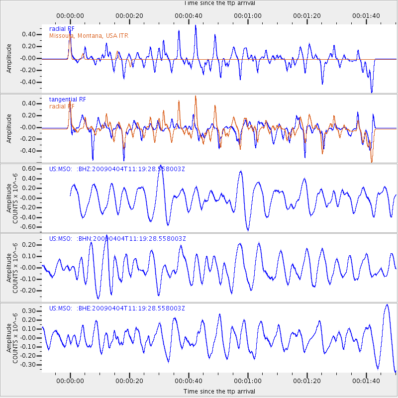
MSO Missoula, Montana, USA - Earthquake Result Viewer
*The percent match for this event was below the threshold and hence no stack was calculated.
| Earthquake location: |
Tonga Islands Region |
| Earthquake latitude/longitude: |
-22.5/-174.7 |
| Earthquake time(UTC): |
2009/04/04 (094) 11:07:12 GMT |
| Earthquake Depth: |
35 km |
| Earthquake Magnitude: |
5.5 MB, 5.4 MS, 5.5 MW, 5.5 MW |
| Earthquake Catalog/Contributor: |
WHDF/NEIC |
|
| Network: |
US United States National Seismic Network |
| Station: |
MSO Missoula, Montana, USA |
| Lat/Lon: |
46.83 N/113.94 W |
| Elevation: |
1264 m |
|
| Distance: |
88.1 deg |
| Az: |
36.813 deg |
| Baz: |
233.801 deg |
| Ray Param: |
$rayparam |
*The percent match for this event was below the threshold and hence was not used in the summary stack. |
|
| Radial Match: |
42.55877 % |
| Radial Bump: |
400 |
| Transverse Match: |
39.666847 % |
| Transverse Bump: |
363 |
| SOD ConfigId: |
2658 |
| Insert Time: |
2010-03-05 02:17:14.211 +0000 |
| GWidth: |
2.5 |
| Max Bumps: |
400 |
| Tol: |
0.001 |
|
Signal To Noise
| Channel | StoN | STA | LTA |
| US:MSO: :BHN:20090404T11:19:28.558003Z | 0.7633057 | 5.2189844E-8 | 6.8373446E-8 |
| US:MSO: :BHE:20090404T11:19:28.558003Z | 0.49796548 | 6.38812E-8 | 1.282844E-7 |
| US:MSO: :BHZ:20090404T11:19:28.558003Z | 1.997706 | 4.2370573E-7 | 2.1209613E-7 |
| Arrivals |
| Ps | |
| PpPs | |
| PsPs/PpSs | |


