You are here: Home > Network List > US - United States National Seismic Network Stations List
> Station MSO Missoula, Montana, USA > Earthquake Result Viewer
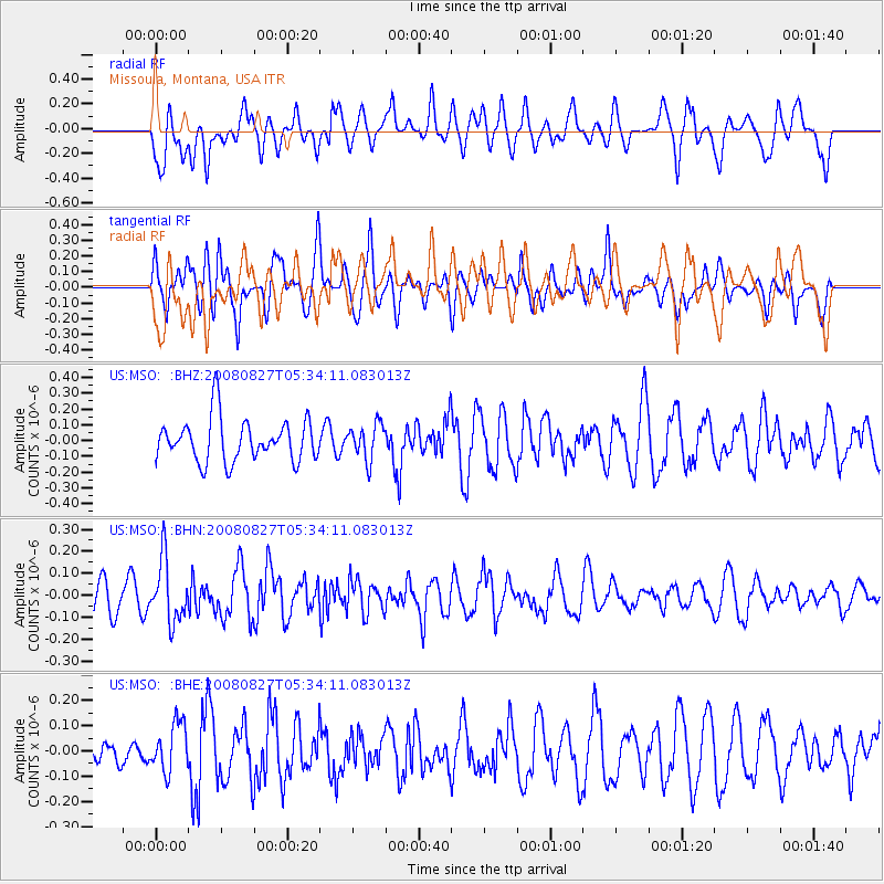
MSO Missoula, Montana, USA - Earthquake Result Viewer
*The percent match for this event was below the threshold and hence no stack was calculated.
| Earthquake location: |
Kuril Islands |
| Earthquake latitude/longitude: |
46.7/152.5 |
| Earthquake time(UTC): |
2008/08/27 (240) 05:24:41 GMT |
| Earthquake Depth: |
65 km |
| Earthquake Magnitude: |
5.5 MB, 5.4 MW, 5.3 MW |
| Earthquake Catalog/Contributor: |
WHDF/NEIC |
|
| Network: |
US United States National Seismic Network |
| Station: |
MSO Missoula, Montana, USA |
| Lat/Lon: |
46.83 N/113.94 W |
| Elevation: |
1264 m |
|
| Distance: |
60.1 deg |
| Az: |
52.218 deg |
| Baz: |
307.64 deg |
| Ray Param: |
$rayparam |
*The percent match for this event was below the threshold and hence was not used in the summary stack. |
|
| Radial Match: |
42.90988 % |
| Radial Bump: |
400 |
| Transverse Match: |
58.51682 % |
| Transverse Bump: |
400 |
| SOD ConfigId: |
2504 |
| Insert Time: |
2010-03-05 02:17:38.246 +0000 |
| GWidth: |
2.5 |
| Max Bumps: |
400 |
| Tol: |
0.001 |
|
Signal To Noise
| Channel | StoN | STA | LTA |
| US:MSO: :BHN:20080827T05:34:11.083013Z | 2.4306107 | 1.3984176E-7 | 5.753359E-8 |
| US:MSO: :BHE:20080827T05:34:11.083013Z | 1.3384113 | 9.532225E-8 | 7.122044E-8 |
| US:MSO: :BHZ:20080827T05:34:11.083013Z | 0.8272608 | 1.1201797E-7 | 1.3540829E-7 |
| Arrivals |
| Ps | |
| PpPs | |
| PsPs/PpSs | |


