You are here: Home > Network List > UW - Pacific Northwest Regional Seismic Network Stations List
> Station UMAT Pilot Rock, OR, USA > Earthquake Result Viewer
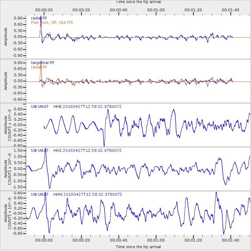
UMAT Pilot Rock, OR, USA - Earthquake Result Viewer
*The percent match for this event was below the threshold and hence no stack was calculated.
| Earthquake location: |
Near Coast Of Chiapas, Mexico |
| Earthquake latitude/longitude: |
14.6/-93.0 |
| Earthquake time(UTC): |
2016/04/27 (118) 12:51:22 GMT |
| Earthquake Depth: |
35 km |
| Earthquake Magnitude: |
5.8 MB |
| Earthquake Catalog/Contributor: |
NEIC PDE/NEIC COMCAT |
|
| Network: |
UW Pacific Northwest Regional Seismic Network |
| Station: |
UMAT Pilot Rock, OR, USA |
| Lat/Lon: |
45.29 N/118.96 W |
| Elevation: |
1318 m |
|
| Distance: |
37.7 deg |
| Az: |
329.595 deg |
| Baz: |
136.036 deg |
| Ray Param: |
$rayparam |
*The percent match for this event was below the threshold and hence was not used in the summary stack. |
|
| Radial Match: |
80.05653 % |
| Radial Bump: |
400 |
| Transverse Match: |
49.066628 % |
| Transverse Bump: |
400 |
| SOD ConfigId: |
7422571 |
| Insert Time: |
2019-04-22 11:31:49.714 +0000 |
| GWidth: |
2.5 |
| Max Bumps: |
400 |
| Tol: |
0.001 |
|
Signal To Noise
| Channel | StoN | STA | LTA |
| UW:UMAT: :HHZ:20160427T12:58:02.978007Z | 4.114011 | 9.649199E-7 | 2.345448E-7 |
| UW:UMAT: :HHN:20160427T12:58:02.978007Z | 2.07621 | 4.5151012E-7 | 2.1746843E-7 |
| UW:UMAT: :HHE:20160427T12:58:02.978007Z | 1.9879143 | 3.7212791E-7 | 1.8719516E-7 |
| Arrivals |
| Ps | |
| PpPs | |
| PsPs/PpSs | |


