You are here: Home > Network List > US - United States National Seismic Network Stations List
> Station MSO Missoula, Montana, USA > Earthquake Result Viewer
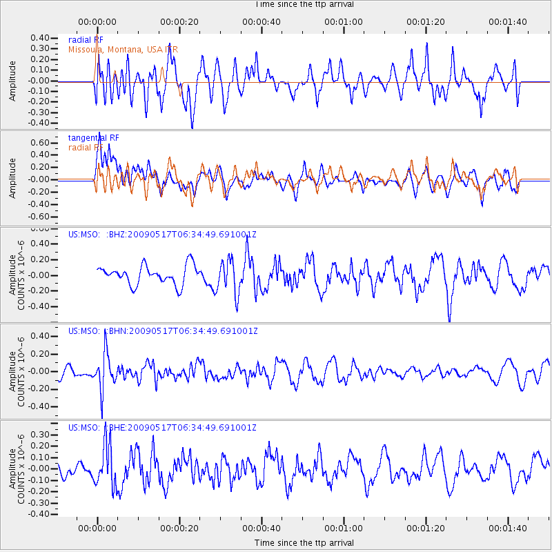
MSO Missoula, Montana, USA - Earthquake Result Viewer
*The percent match for this event was below the threshold and hence no stack was calculated.
| Earthquake location: |
Tonga Islands |
| Earthquake latitude/longitude: |
-16.8/-173.5 |
| Earthquake time(UTC): |
2009/05/17 (137) 06:23:03 GMT |
| Earthquake Depth: |
67 km |
| Earthquake Magnitude: |
5.5 MB, 5.6 MW, 5.6 MW |
| Earthquake Catalog/Contributor: |
WHDF/NEIC |
|
| Network: |
US United States National Seismic Network |
| Station: |
MSO Missoula, Montana, USA |
| Lat/Lon: |
46.83 N/113.94 W |
| Elevation: |
1264 m |
|
| Distance: |
82.9 deg |
| Az: |
36.622 deg |
| Baz: |
236.312 deg |
| Ray Param: |
$rayparam |
*The percent match for this event was below the threshold and hence was not used in the summary stack. |
|
| Radial Match: |
45.190212 % |
| Radial Bump: |
400 |
| Transverse Match: |
50.139084 % |
| Transverse Bump: |
400 |
| SOD ConfigId: |
2760 |
| Insert Time: |
2010-03-05 02:18:32.032 +0000 |
| GWidth: |
2.5 |
| Max Bumps: |
400 |
| Tol: |
0.001 |
|
Signal To Noise
| Channel | StoN | STA | LTA |
| US:MSO: :BHN:20090517T06:34:49.691001Z | 3.6000698 | 2.0691206E-7 | 5.7474455E-8 |
| US:MSO: :BHE:20090517T06:34:49.691001Z | 2.114879 | 1.8967194E-7 | 8.9684534E-8 |
| US:MSO: :BHZ:20090517T06:34:49.691001Z | 1.8001401 | 2.1648508E-7 | 1.2026013E-7 |
| Arrivals |
| Ps | |
| PpPs | |
| PsPs/PpSs | |


