You are here: Home > Network List > US - United States National Seismic Network Stations List
> Station MSO Missoula, Montana, USA > Earthquake Result Viewer
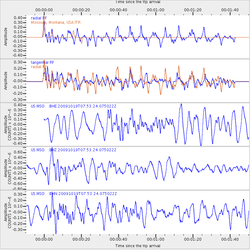
MSO Missoula, Montana, USA - Earthquake Result Viewer
*The percent match for this event was below the threshold and hence no stack was calculated.
| Earthquake location: |
Samoa Islands Region |
| Earthquake latitude/longitude: |
-15.4/-173.0 |
| Earthquake time(UTC): |
2009/10/19 (292) 07:41:38 GMT |
| Earthquake Depth: |
10 km |
| Earthquake Magnitude: |
5.8 MW, 5.4 MS, 5.4 MB, 5.8 MW |
| Earthquake Catalog/Contributor: |
WHDF/NEIC |
|
| Network: |
US United States National Seismic Network |
| Station: |
MSO Missoula, Montana, USA |
| Lat/Lon: |
46.83 N/113.94 W |
| Elevation: |
1264 m |
|
| Distance: |
81.5 deg |
| Az: |
36.538 deg |
| Baz: |
236.741 deg |
| Ray Param: |
$rayparam |
*The percent match for this event was below the threshold and hence was not used in the summary stack. |
|
| Radial Match: |
58.12922 % |
| Radial Bump: |
400 |
| Transverse Match: |
50.74373 % |
| Transverse Bump: |
400 |
| SOD ConfigId: |
2622 |
| Insert Time: |
2010-03-05 02:20:17.098 +0000 |
| GWidth: |
2.5 |
| Max Bumps: |
400 |
| Tol: |
0.001 |
|
Signal To Noise
| Channel | StoN | STA | LTA |
| US:MSO: :BHZ:20091019T07:53:24.075022Z | 3.6502259 | 3.7538857E-7 | 1.0283982E-7 |
| US:MSO: :BHN:20091019T07:53:24.075022Z | 1.039111 | 1.3195346E-7 | 1.2698688E-7 |
| US:MSO: :BHE:20091019T07:53:24.075022Z | 1.0143666 | 1.8087286E-7 | 1.7831113E-7 |
| Arrivals |
| Ps | |
| PpPs | |
| PsPs/PpSs | |


