You are here: Home > Network List > US - United States National Seismic Network Stations List
> Station MSO Missoula, Montana, USA > Earthquake Result Viewer
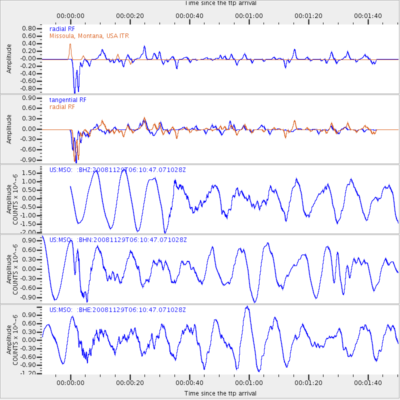
MSO Missoula, Montana, USA - Earthquake Result Viewer
*The percent match for this event was below the threshold and hence no stack was calculated.
| Earthquake location: |
Fiji Islands Region |
| Earthquake latitude/longitude: |
-18.7/-177.7 |
| Earthquake time(UTC): |
2008/11/29 (334) 05:59:16 GMT |
| Earthquake Depth: |
386 km |
| Earthquake Magnitude: |
5.7 MB, 6.0 MW, 5.9 MW |
| Earthquake Catalog/Contributor: |
WHDF/NEIC |
|
| Network: |
US United States National Seismic Network |
| Station: |
MSO Missoula, Montana, USA |
| Lat/Lon: |
46.83 N/113.94 W |
| Elevation: |
1264 m |
|
| Distance: |
86.8 deg |
| Az: |
38.091 deg |
| Baz: |
238.389 deg |
| Ray Param: |
$rayparam |
*The percent match for this event was below the threshold and hence was not used in the summary stack. |
|
| Radial Match: |
86.94341 % |
| Radial Bump: |
395 |
| Transverse Match: |
91.57359 % |
| Transverse Bump: |
337 |
| SOD ConfigId: |
2658 |
| Insert Time: |
2010-03-05 02:20:24.851 +0000 |
| GWidth: |
2.5 |
| Max Bumps: |
400 |
| Tol: |
0.001 |
|
Signal To Noise
| Channel | StoN | STA | LTA |
| US:MSO: :BHN:20081129T06:10:47.071028Z | 0.94255334 | 6.6371183E-7 | 7.041637E-7 |
| US:MSO: :BHE:20081129T06:10:47.071028Z | 1.8245974 | 4.9906185E-7 | 2.7351888E-7 |
| US:MSO: :BHZ:20081129T06:10:47.071028Z | 0.8881895 | 1.0243646E-6 | 1.1533176E-6 |
| Arrivals |
| Ps | |
| PpPs | |
| PsPs/PpSs | |


