You are here: Home > Network List > US - United States National Seismic Network Stations List
> Station MSO Missoula, Montana, USA > Earthquake Result Viewer
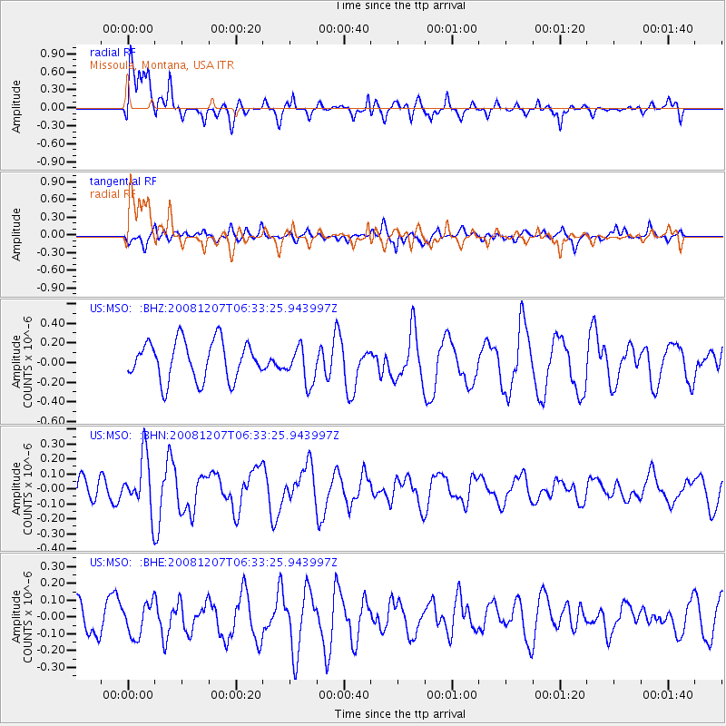
MSO Missoula, Montana, USA - Earthquake Result Viewer
*The percent match for this event was below the threshold and hence no stack was calculated.
| Earthquake location: |
Northern Mid-Atlantic Ridge |
| Earthquake latitude/longitude: |
13.4/-44.8 |
| Earthquake time(UTC): |
2008/12/07 (342) 06:23:09 GMT |
| Earthquake Depth: |
10 km |
| Earthquake Magnitude: |
5.6 MB, 5.3 MS, 5.7 MW |
| Earthquake Catalog/Contributor: |
WHDF/NEIC |
|
| Network: |
US United States National Seismic Network |
| Station: |
MSO Missoula, Montana, USA |
| Lat/Lon: |
46.83 N/113.94 W |
| Elevation: |
1264 m |
|
| Distance: |
66.1 deg |
| Az: |
315.441 deg |
| Baz: |
95.947 deg |
| Ray Param: |
$rayparam |
*The percent match for this event was below the threshold and hence was not used in the summary stack. |
|
| Radial Match: |
65.68024 % |
| Radial Bump: |
400 |
| Transverse Match: |
57.832127 % |
| Transverse Bump: |
400 |
| SOD ConfigId: |
2658 |
| Insert Time: |
2010-03-05 02:20:31.605 +0000 |
| GWidth: |
2.5 |
| Max Bumps: |
400 |
| Tol: |
0.001 |
|
Signal To Noise
| Channel | StoN | STA | LTA |
| US:MSO: :BHN:20081207T06:33:25.943997Z | 1.7482764 | 1.8608365E-7 | 1.0643836E-7 |
| US:MSO: :BHE:20081207T06:33:25.943997Z | 1.309274 | 9.9818614E-8 | 7.623967E-8 |
| US:MSO: :BHZ:20081207T06:33:25.943997Z | 0.96447057 | 1.8984957E-7 | 1.968433E-7 |
| Arrivals |
| Ps | |
| PpPs | |
| PsPs/PpSs | |


