You are here: Home > Network List > US - United States National Seismic Network Stations List
> Station MSO Missoula, Montana, USA > Earthquake Result Viewer
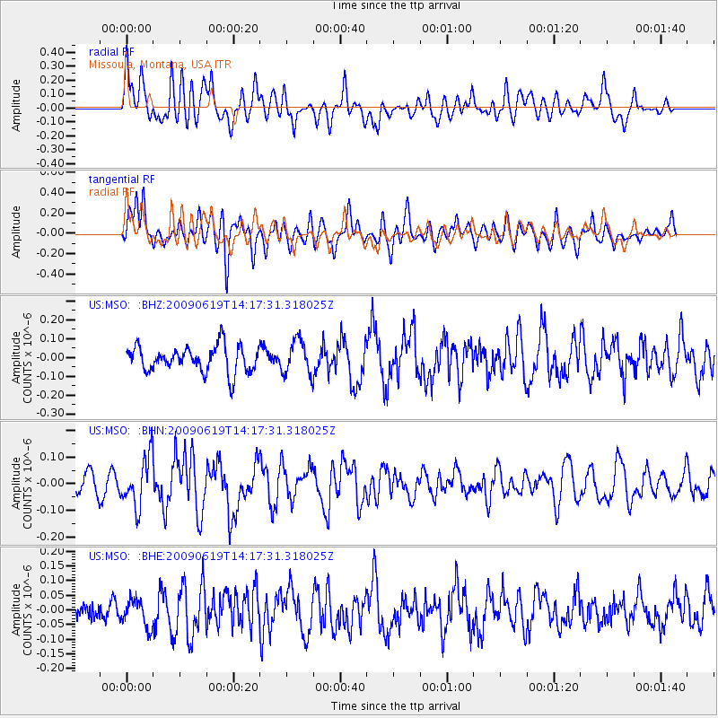
MSO Missoula, Montana, USA - Earthquake Result Viewer
*The percent match for this event was below the threshold and hence no stack was calculated.
| Earthquake location: |
Eastern Mediterranean Sea |
| Earthquake latitude/longitude: |
35.4/28.5 |
| Earthquake time(UTC): |
2009/06/19 (170) 14:04:59 GMT |
| Earthquake Depth: |
28 km |
| Earthquake Magnitude: |
5.6 MB, 5.6 MS, 5.8 MW, 5.8 MW |
| Earthquake Catalog/Contributor: |
WHDF/NEIC |
|
| Network: |
US United States National Seismic Network |
| Station: |
MSO Missoula, Montana, USA |
| Lat/Lon: |
46.83 N/113.94 W |
| Elevation: |
1264 m |
|
| Distance: |
91.5 deg |
| Az: |
335.22 deg |
| Baz: |
29.931 deg |
| Ray Param: |
$rayparam |
*The percent match for this event was below the threshold and hence was not used in the summary stack. |
|
| Radial Match: |
60.167084 % |
| Radial Bump: |
400 |
| Transverse Match: |
64.49318 % |
| Transverse Bump: |
400 |
| SOD ConfigId: |
2648 |
| Insert Time: |
2010-03-05 02:20:35.247 +0000 |
| GWidth: |
2.5 |
| Max Bumps: |
400 |
| Tol: |
0.001 |
|
Signal To Noise
| Channel | StoN | STA | LTA |
| US:MSO: :BHN:20090619T14:17:31.318025Z | 2.915947 | 9.517301E-8 | 3.26388E-8 |
| US:MSO: :BHE:20090619T14:17:31.318025Z | 1.0825989 | 4.718665E-8 | 4.3586457E-8 |
| US:MSO: :BHZ:20090619T14:17:31.318025Z | 1.3326402 | 9.089193E-8 | 6.820441E-8 |
| Arrivals |
| Ps | |
| PpPs | |
| PsPs/PpSs | |


