You are here: Home > Network List > TA - USArray Transportable Network (new EarthScope stations) Stations List
> Station J20K Nowitna River, AK, USA > Earthquake Result Viewer
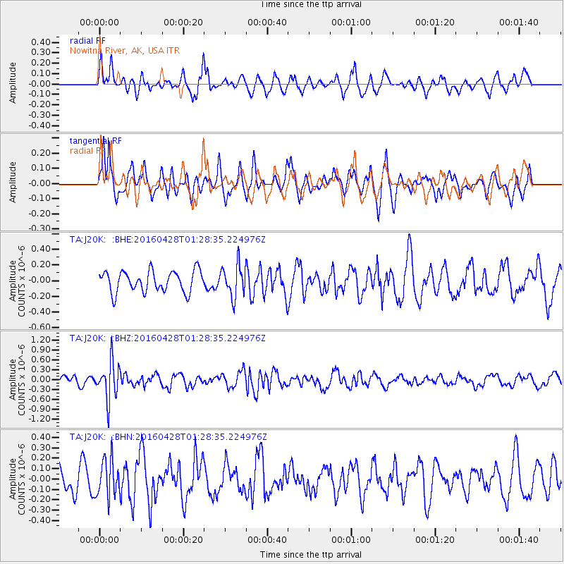
J20K Nowitna River, AK, USA - Earthquake Result Viewer
*The percent match for this event was below the threshold and hence no stack was calculated.
| Earthquake location: |
Solomon Islands |
| Earthquake latitude/longitude: |
-6.1/155.0 |
| Earthquake time(UTC): |
2016/04/28 (119) 01:17:13 GMT |
| Earthquake Depth: |
128 km |
| Earthquake Magnitude: |
5.6 MB |
| Earthquake Catalog/Contributor: |
NEIC PDE/NEIC ALERT |
|
| Network: |
TA USArray Transportable Network (new EarthScope stations) |
| Station: |
J20K Nowitna River, AK, USA |
| Lat/Lon: |
64.18 N/154.15 W |
| Elevation: |
314 m |
|
| Distance: |
79.6 deg |
| Az: |
20.211 deg |
| Baz: |
231.668 deg |
| Ray Param: |
$rayparam |
*The percent match for this event was below the threshold and hence was not used in the summary stack. |
|
| Radial Match: |
57.6539 % |
| Radial Bump: |
400 |
| Transverse Match: |
63.29123 % |
| Transverse Bump: |
375 |
| SOD ConfigId: |
7422571 |
| Insert Time: |
2019-04-22 11:49:38.177 +0000 |
| GWidth: |
2.5 |
| Max Bumps: |
400 |
| Tol: |
0.001 |
|
Signal To Noise
| Channel | StoN | STA | LTA |
| TA:J20K: :BHZ:20160428T01:28:35.224976Z | 5.051741 | 5.8179853E-7 | 1.1516792E-7 |
| TA:J20K: :BHN:20160428T01:28:35.224976Z | 1.4182799 | 1.7890983E-7 | 1.2614565E-7 |
| TA:J20K: :BHE:20160428T01:28:35.224976Z | 1.5224587 | 2.056588E-7 | 1.3508334E-7 |
| Arrivals |
| Ps | |
| PpPs | |
| PsPs/PpSs | |


