You are here: Home > Network List > US - United States National Seismic Network Stations List
> Station MSO Missoula, Montana, USA > Earthquake Result Viewer
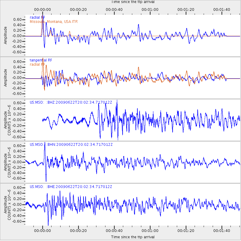
MSO Missoula, Montana, USA - Earthquake Result Viewer
*The percent match for this event was below the threshold and hence no stack was calculated.
| Earthquake location: |
Andreanof Islands, Aleutian Is. |
| Earthquake latitude/longitude: |
51.3/-178.2 |
| Earthquake time(UTC): |
2009/06/22 (173) 19:55:24 GMT |
| Earthquake Depth: |
35 km |
| Earthquake Magnitude: |
5.6 MB, 5.6 MW, 5.6 MW |
| Earthquake Catalog/Contributor: |
WHDF/NEIC |
|
| Network: |
US United States National Seismic Network |
| Station: |
MSO Missoula, Montana, USA |
| Lat/Lon: |
46.83 N/113.94 W |
| Elevation: |
1264 m |
|
| Distance: |
41.1 deg |
| Az: |
70.04 deg |
| Baz: |
300.701 deg |
| Ray Param: |
$rayparam |
*The percent match for this event was below the threshold and hence was not used in the summary stack. |
|
| Radial Match: |
53.492325 % |
| Radial Bump: |
400 |
| Transverse Match: |
63.49163 % |
| Transverse Bump: |
400 |
| SOD ConfigId: |
2648 |
| Insert Time: |
2010-03-05 02:20:37.492 +0000 |
| GWidth: |
2.5 |
| Max Bumps: |
400 |
| Tol: |
0.001 |
|
Signal To Noise
| Channel | StoN | STA | LTA |
| US:MSO: :BHN:20090622T20:02:34.717012Z | 5.0903406 | 2.556233E-7 | 5.0217324E-8 |
| US:MSO: :BHE:20090622T20:02:34.717012Z | 3.0361662 | 2.2137559E-7 | 7.291287E-8 |
| US:MSO: :BHZ:20090622T20:02:34.717012Z | 2.6383364 | 2.5883946E-7 | 9.810707E-8 |
| Arrivals |
| Ps | |
| PpPs | |
| PsPs/PpSs | |


