You are here: Home > Network List > TA - USArray Transportable Network (new EarthScope stations) Stations List
> Station M31M Drury Creek, Yukon, CA > Earthquake Result Viewer
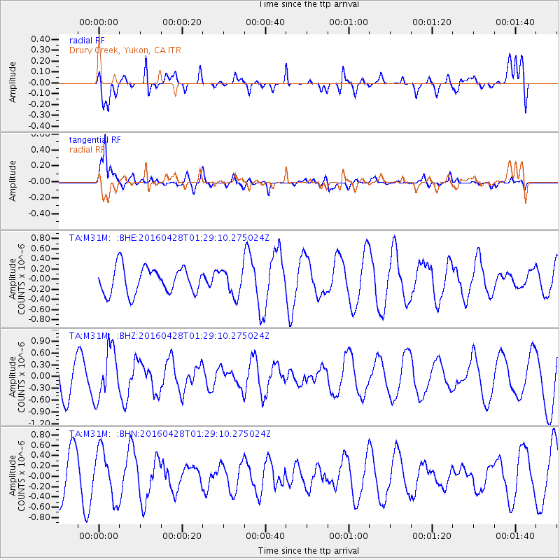
M31M Drury Creek, Yukon, CA - Earthquake Result Viewer
*The percent match for this event was below the threshold and hence no stack was calculated.
| Earthquake location: |
Solomon Islands |
| Earthquake latitude/longitude: |
-6.1/155.0 |
| Earthquake time(UTC): |
2016/04/28 (119) 01:17:13 GMT |
| Earthquake Depth: |
128 km |
| Earthquake Magnitude: |
5.6 MB |
| Earthquake Catalog/Contributor: |
NEIC PDE/NEIC ALERT |
|
| Network: |
TA USArray Transportable Network (new EarthScope stations) |
| Station: |
M31M Drury Creek, Yukon, CA |
| Lat/Lon: |
62.20 N/134.39 W |
| Elevation: |
639 m |
|
| Distance: |
86.5 deg |
| Az: |
26.304 deg |
| Baz: |
250.055 deg |
| Ray Param: |
$rayparam |
*The percent match for this event was below the threshold and hence was not used in the summary stack. |
|
| Radial Match: |
59.433807 % |
| Radial Bump: |
400 |
| Transverse Match: |
83.82724 % |
| Transverse Bump: |
400 |
| SOD ConfigId: |
7422571 |
| Insert Time: |
2019-04-22 11:49:45.324 +0000 |
| GWidth: |
2.5 |
| Max Bumps: |
400 |
| Tol: |
0.001 |
|
Signal To Noise
| Channel | StoN | STA | LTA |
| TA:M31M: :BHZ:20160428T01:29:10.275024Z | 2.0303893 | 6.323729E-7 | 3.1145402E-7 |
| TA:M31M: :BHN:20160428T01:29:10.275024Z | 1.1801547 | 4.9474244E-7 | 4.1921834E-7 |
| TA:M31M: :BHE:20160428T01:29:10.275024Z | 0.9822797 | 2.544777E-7 | 2.5906846E-7 |
| Arrivals |
| Ps | |
| PpPs | |
| PsPs/PpSs | |


